|
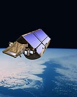
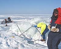
Paris (ESA) Apr 19, 2005 The northernmost part of the Baltic Sea, between Finland and Sweden, recently provided an ideal location for scientists to successfully address critical issues relating to sea ice validation before CryoSat is launched in September. Unlike last year's CryoSat Validation Experiments (CryoVEx 2004), which focussed on land ice and took place in Greenland and the Canadian Arctic, the recent validation activities in the Baltic scrutinised issues relating to sea ice. The experiment examined the possible sources of error that could arise in the sea-ice thickness maps that will be generated using data from ESA's ice mission CryoSat. Errors can arise, for example, where a snow layer is present on top of the sea ice. The weight of the snow tends to push the ice floes lower into the water, so that CryoSat, which translates the height of the ice surface above the waterline into ice thickness data, would underestimate the true thickness of the ice. Validation campaigns, thus, form a critical component of the whole mission; they provide the only means to reach a comprehensive assessment of how accurate CryoSat-derived ice thickness maps are. Contributing to this aspect of the mission, an intensive two-week validation campaign was successfully carried out during March in the frozen Bay of Bothnia, which lies in the northernmost arm of the Baltic Sea. The campaign involved scientists from a number of institutes, namely, the Finnish Institute of Marine Research (FIMR), the Alfred Wegner Institute (AWI) from Germany, the Helsinki University of Technology (HUT), the Scottish Association of Marine Research (SAMS) and the Swedish Institute of Meteorology and Hydrology (SMHI). Ground and helicopter measurements were performed from the research vessel Aranda. The CryoSat validation activities were co-funded by ESA together with the National Technology Agency of Finland (TEKES) and other national and European sources. In this coordinated effort, valuable information on sea ice properties and CryoSat validation measurements were collected from the surface of the ice, and from the air using the AWI Dornier 228 and HUT SC7 Skyvan aircrafts. From the air, 1600 kilometres of data were collected over the Bay of Bothnia and from several altitudes along a calibration line that was established close to the island of Hailuoto. The calibration line covered ice of varying thickness, from as little as 19 centimetres to as much as 20 metres and also included ice featuring different topography, from the smooth and level to very rough ridged forms. In addition, a helicopter suspending an electromagnetic sensor known as EM-bird, took many kilometres worth of ice thickness measurements underlying the airborne flight path. This will be compared with ice thickness data derived using the radar altimeter on board the aircraft to determine overall accuracy. The most arduous task was undoubtedly collecting the ground measurements at various points along the calibration line. Snow thickness and snow properties were measured and holes were drilled through the ice to measure the thickness.
|