|
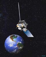
Successful Transmission from Orbit 22,300 Miles Above the Earth White Plains NY, (SPX) Aug 17, 2006 ITT has announced that the GOES-N satellite, in orbit 22,300 miles above the equator and carrying primary payload instruments produced by ITT's Space Systems Division, has transmitted its first visible and infrared (IR) images of Earth. The GOES-N, now called GOES-13, is the latest in a series of Earth-monitoring Geostationary Operational Environmental Satellites built for NASA and the National Oceanic and Atmospheric Administration (NOAA). It was launched on May 24 aboard a Boeing Delta IV rocket, reached orbit on May 31, and, after a period of testing, transmitted its initial visible image on June 22 and is now providing both visible and infrared images. The GOES array of satellites monitors the Earth's atmosphere in visible and infrared wavelengths. By measuring moisture content and tracking weather systems, they provide data to meteorologists to help improve the accuracy of forecasts. As a contractor to NASA on the GOES-N project, ITT built the imager and sounder that acquire the high-resolution visible and infrared data, as well as temperature and moisture profiles of the atmosphere. "ITT is proud to be part of yet another successful GOES mission," said Chris Young, President of the Space Systems Division. "ITT's imager and sounder aboard GOES-13 continually transmit data to ground terminals for processing and broadcasting to weather service offices through the Western Hemisphere." The ITT imager and sounder provide two valuable features -- (1) flexible scan and (2) simultaneous and independent imaging and sounding. Flexible scan offers small-scale area imaging that allows meteorologists to take pictures of local weather trouble spots in order to improve short-term forecasts over local areas. Simultaneous and independent imaging and sounding enhances forecast accuracy by providing multiple measurements of weather phenomena. The imager senses radiant energy and reflected solar energy from the Earth's surface and atmosphere. It can detect changes in temperature and variations in low-level moisture, and it can track hurricanes from their earliest formation as a tropical wave. It allows meteorologists to issue warnings about high-velocity winds or winter storms well in advance of their occurrence. The multi-spectral sounder uses sensors to collect and identify fluctuations within the Earth's atmosphere. These variations provide critically important data for computer models that help produce mid- and long- range forecasts. Community Email This Article Comment On This Article Related Links Weather News at TerraDaily.com Weather News at TerraDaily.com
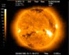 Charlotte NC (SPX) Aug 17, 2006
The U.S. National Oceanic and Atmospheric Administration's (NOAA) latest Geostationary Operational Environmental Satellite (GOES-13) successfully captured its first image of the sun recently using Goodrich Corporation's (NYSE: GR) Solar X-ray Imager (SXI) telescope mirror assembly. GOES-13 is the latest in a series of earth monitoring satellites. It provides continuous monitoring of both earth and space weather events. |
|
| The content herein, unless otherwise known to be public domain, are Copyright 1995-2006 - SpaceDaily.AFP and UPI Wire Stories are copyright Agence France-Presse and United Press International. ESA PortalReports are copyright European Space Agency. All NASA sourced material is public domain. Additionalcopyrights may apply in whole or part to other bona fide parties. Advertising does not imply endorsement,agreement or approval of any opinions, statements or information provided by SpaceDaily on any Web page published or hosted by SpaceDaily. Privacy Statement |