|
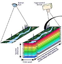
Redondo Beach - Dec 04, 2003 The Northrop Grumman-built Hyperion hyperspectal imager aboard NASA's Earth Observing-1 satellite celebrated its third anniversary on-orbit Nov. 21. Originally intended to be on-orbit for one year, Hyperion has now operated for 300 percent of its original mission life. During its years on-orbit, Hyperion has taken more than 10,000 images in 220 spectral bands of features and phenomena on Earth, including volcanoes, forests, fires and vegetation. These images have been supplied to commercial users and science teams around the country through a partnership between NASA and the United States Geological Survey. Hyperspectral imaging helps improve productivity and management of industries based on natural resources, such as agriculture, forestry and mining, as well as defense. By providing very detailed information, hyperspectral imaging enables users to make informed decisions, which are cost-effective and beneficial in the long run. "Hyperion has done a great job on-orbit for NASA and the scientific community, producing a wealth of data for remote sensing purposes," said Jay Marmo, who led development of the prototype for Hyperion at Northrop Grumman Space Technology. "It has also demonstrated the exceptional reliability that characterizes our systems, spacecraft and sensors." Hyperion fulfilled its mission as a part of NASA's New Millennium Program after one year on-orbit and has been in an extended mission since then. The New Millennium Program was designed to validate revolutionary technologies that will reduce the cost and increase the capabilities for future land imaging. Northrop Grumman has decades of experience as both an instrument developer and a systems prime contractor, building highly reliable spacecraft and sensors for remote sensing missions. The company has designed and developed airborne and spaceborne hyperspectral instruments since 1989. Its hyperspectral instruments have completed thousands of hours of operations on many platforms, taking images of metropolitan, agricultural and environmentally sensitive areas. Based in Redondo Beach, Calif., Northrop Grumman Space Technology is leader in the design and development of systems, satellites and sensors for remote sensing and environmental missions. Community Email This Article Comment On This Article Related Links Northrop Grumman Space Technology SpaceDaily Search SpaceDaily Subscribe To SpaceDaily Express Earth Observation News - Suppiliers, Technology and Application
The National Geospatial-Intelligence Agency (NGA) Friday awarded a $24-million satellite imagery contract extension to Space Imaging. This ClearView contract option enables the NGA to acquire additional commercial imagery from Space Imaging's IKONOS satellite for another year. |
|
| The content herein, unless otherwise known to be public domain, are Copyright 1995-2006 - SpaceDaily.AFP and UPI Wire Stories are copyright Agence France-Presse and United Press International. ESA PortalReports are copyright European Space Agency. All NASA sourced material is public domain. Additionalcopyrights may apply in whole or part to other bona fide parties. Advertising does not imply endorsement,agreement or approval of any opinions, statements or information provided by SpaceDaily on any Web page published or hosted by SpaceDaily. Privacy Statement |