|
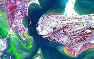
Sydney - November 22 1999 - With pin-point precision, an Australian eye-in-the-sky is aiding mineral exploration and at the same time monitoring the health of our environment. The eye is HyMap , an aircraft-mounted imaging instrument that can detect and identify specific minerals and other chemical compounds from the unique wavelengths of light they reflect. These compounds include plant chlorophyll and lignin that can provide important clues to plant health. Caption: "Hymap image of Port Hedland harbour with dust affected mangroves shown in yellow/magenta tones and dust free mangroves in green. - Image by CSIRO/Integrated Spectronics An Australian company, Integrated Spectronics Pty Ltd, developed HyMap in collaboration with CSIRO. Known as a hyperspectral scanner, HyMap is the best of its type outside NASA, says Dr Jon Huntington, Leader of the Mineral Mapping Technologies Group at CSIRO Exploration and Mining. "Being airborne, it can rapidly survey areas in remote and otherwise inaccessible or environmentally sensitive places," he says. "HyMap gives you the ability to map areas at a level of geological and environmental detail not available by any other means and without anyone needing to set foot on the ground." CSIRO is currently coordinating a program to acquire and evaluate hyperspectral data for a range of applications from sites around Australia. One of the HyMap� projects under way is in the remote Pilbara region of Western Australia. Dust from large mining operations in this region is a major environmental and social issue facing the mining industry. In Port Hedland, where Australia's largest tonnages of bulk materials are handled, BHP has initiated a program to investigate the effects of iron-ore dust on the mangroves lining the coastline and tidal creeks. Along with their environmental role, the mangroves are important in protecting the port's facilities from erosion and sedimentation. "CSIRO is using HyMap to determine the distribution and amount of dust on the mangroves. This will give us a better understanding of the dust's impact on the mangrove ecosystem, and provide BHP Iron Ore with a cost effective tool for assessing the improvements effected through their dust management program, " says Ms Cindy Ong from the Mineral Mapping Technologies Group. "HyMap gives the mining industry a quantitative tool that can monitor the environment in an efficient and objective manner," she says. "Current methods of monitoring mangrove health are time consuming, expensive and often difficult. The results are also subjective as assessment of dust levels and the health of individual mangroves rely heavily on a field researcher's ability to access the mangroves and on personal observation." Mr Tom Cudahy, also from the Mineral Mapping Technologies Group, is using HyMap data to produce new types of mineralogical maps of parts of the Pilbara in Western Australia. From these, exploration geologists can identify specific areas containing signatures of potentially hidden mineral deposits. "Exploration companies can quickly target areas of interest without spending time and money trying to cover huge areas on the ground," he says. Mr Cudahy is also involved in assessing and monitoring acid drainage from sulfide-bearing mine waste � one of the major environmental impacts of the mining industry. "The HyMap data is giving us a better understanding of the processes and effects of acid rock drainage that should lead to more effective remedial programs," he says. "Monitoring the effectiveness of any remedial program needs quantitative, reproducible information. Hyperspectral sensing is one of the few technologies that can do this." HyMap is also being used to assess and monitor the state of coral health on the Great Barrier Reef, the extent of salinity creeping across the land and the progress of mine rehabilitation programs. HyMap uses 128 separate wavelengths of light or colours � from the visible to infrared � to distinguish one mineral or molecule from another. By contrast, existing satellite imaging uses only three to six wavelengths when mapping the surface of the earth. Once the value of hyperspectral sensing from aircraft has been more widely recognised, researchers expect a suite of satellite sensors to be launched to complement the airborne systems and to operate continually on a global scale. Dr Huntington believes that producing this world class technology is not the end of the game. "We need to further research ways to mine this data, turn it into information and make it accessible and of increasing value to clients. To do this, CSIRO is now focussing on developing data analysis software and new types of information products derived from HyMap data", he says. "As Australia's mining industry competes in the global market place and expands into new and unfamiliar territories, these hyperspectral technologies should bring greatly increased efficiency and a competitive advantage for Australia � the rewards from such persistence could be considerable."
Email This Article Comment On This Article Related Links Space
 Calcutta, India (SPX) Dec 28, 2005
The successful launch Thursday of India's heaviest satellite from spaceport of Kourou in French Guyana may have boosted the country's space research efforts to yet another level, but it has also lifted the spirits of at least three Direct-To-Home televisions broadcasters, one of which has been waiting for years to launch its services in India. |
|
|
|
|
|
|
|
|
|
|
|
|
|
| The content herein, unless otherwise known to be public domain, are Copyright 1995-2006 - SpaceDaily.AFP and UPI Wire Stories are copyright Agence France-Presse and United Press International. ESA PortalReports are copyright European Space Agency. All NASA sourced material is public domain. Additionalcopyrights may apply in whole or part to other bona fide parties. Advertising does not imply endorsement,agreement or approval of any opinions, statements or information provided by SpaceDaily on any Web page published or hosted by SpaceDaily. Privacy Statement |