|
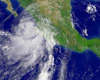
Mexico City (AFP) Sep 16, 2006 Hurricane Lane, packing gale-force winds and driving rain, slammed into the Pacific coast of Mexico late Saturday, causing flooding in the port of Mazatlan and other parts of the region, officials said. The hurricane came ashore near the Villamoros Peninsula and the town of Culiacan as a major Category Three storm on the five-category Saffir-Simpson scale, but quickly weakened and was downgraded to Category One. At 0300 GMT Sunday, Lane was packing maximum sustained winds near 140 kilometers (85 miles) per hour, with higher gusts, said the US National Hurricane Center (NHC) in Miami. The eye of the hurricane was now located about 50 kilometers (30 miles) north-northwest of the city of Culiacan and 240 kilometers (150 miles) north-northwest of Mazatlan, a key port and tourist resort, the NHC said. Lane was moving toward the north at near 13 kilometers (eight miles) per hour and was expected to further weaken over land Sunday. Mexico's interior ministry warned of heavy rains, intense winds and threats of flooding and mudslides. "Recreation and fishing should be suspended in the area," the Mexican statement said. About 100 people were due to be evacuated in Mazatlan due to flooding in low lying areas, said Alfredo Galaviz, a local civil protection official. Two rivers that empty into the sea there have breached their banks, but no casualties were reported. The states of Jalisco, Colima and Nayarit on the west coast were expected to feel the brunt of Lane, and to a lesser degree Sinaloa and Baja California Sur. A hurricane warning remained in effect for the Pacific coast of Mexico from Mazatlan to Altata, the NHC said.
Source: Agence France-Presse Community Email This Article Comment On This Article Related Links Bring Order To A World Of Disasters A world of storm and tempest Weather News at TerraDaily.com Bringing Order To A World Of Disasters When the Earth Quakes A world of storm and tempest
 Greenbelt MD (SPX) Sep 13, 2006
Hurricane Florence, Tropical Storm Gordon, and the newly formed Tropical Depression #8 can be seen in this satellite image from the National Oceanic and Atmospheric Administration's Geostationary Operational Environmental Satellite (GOES). This satellite image was captured on Tues. Sept. 12 at 7:04 a.m. EDT. This data was processed by NASA's GOES Project at the Goddard Space Flight Center, Greenbelt, Md. |
|
| The content herein, unless otherwise known to be public domain, are Copyright 1995-2006 - SpaceDaily.AFP and UPI Wire Stories are copyright Agence France-Presse and United Press International. ESA PortalReports are copyright European Space Agency. All NASA sourced material is public domain. Additionalcopyrights may apply in whole or part to other bona fide parties. Advertising does not imply endorsement,agreement or approval of any opinions, statements or information provided by SpaceDaily on any Web page published or hosted by SpaceDaily. Privacy Statement |