|
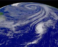
London (AFP) Sep 19, 2006 Britain is bracing for strong winds as the tail-end of a hurricane threatens parts of the country, weather experts said Tuesday. The remnants of Hurricane Gordon are expected to hit British shores later this week, bringing gusts up to 75 miles (121 kilometres) per hour particularly to Northern Ireland and Scotland, forecasters said. "Through this week it is expected to lose its strength, but the effects of the storm will be felt closer to home as the remnants influence the weather across the UK during the second half of the week," said the Met Office. As well as high winds the hurricane could also bring heavy, prolonged rain in its wake, especially in northern and western areas, as well as large sea swells on south-west and west-facing beaches. The warning came as American and European players began practicing for the Ryder Cup at the K-Club, 30 miles (48 kilometres) west of the Irish capital Dublin. Reports suggested the start of the golf tournament could be clouded by showers, but the worst should be over by the weekend when the sun is due to return. Hurricane Gordon was speeding Tuesday toward the Azores Islands, the US National Hurricane Center said Tuesday. Packing maximum sustained winds near 160 kilometers (100 miles) per hour, Gordon, a Category Two hurricane in the five-category Saffir-Simpson scale, was located 1140 kilometers (710 miles) west of the Azores, at 0600 GMT, it said.
earlier related report The civil protection service urged the islands's roughly 240,000 residents to stay indoors while the archipelago's regional government ordered schools to be shut and fishermen to stay on land on Wednesday because of the storm. Gordon was initially expected to weaken to a tropical storm by the time it struck the Azores but it is now expected to hit the islands as a Category 2 hurricane on Tuesday evening. "A hurricane of this level is already very destructive," national weather office meteorologist Ilda Nova told cable news channel Sic-Noticias. A Category 2 storm on the five-step Saffir Simpson scale of hurricane intensity can cause damage to windows and roofs of buildings, blow down trees and cause flooding in coastal and low-lying areas. Tropical storms often pass near the Azores islands, located about 1,200 kilometres (750 miles) west of mainland Portugal, but a direct hit by a hurricane is rare. Gordon is forecast to produce waves of up to 12 metres (40 feet) high and is expected to disrupt air and maritime travel. Emergency services boosted the number personnel who will be on call overnight and advised residents to close doors and windows, clear storm sewers, move livestock to safe areas and lock away farm equipment and garbage bins. Laura Medeiros, a 33-year-old resident of Sao Miguel, the largest and most populous island in the volcanic archipelago, said she planned to spend the night at the home of her mother-in-law along with her two young children. "My house is old and isolated," she told the Lusa news agency. Some residents however said they were not fazed by the approaching storm. "I think we're strong and are suitably prepared for situations like the one which is coming. If this wasn't the case, I would have left the archipelago a long time ago," 54-year-old Sao Miguel resident Joao Botelho told the agency. Forecasters said Gordon should eventually be absorbed by a larger weather system which was expected to approach northwestern Portugal and Spain on Thursday bringing with it heavy rain.
Hurricanes Gordon, Helene poised to strike Atlantic islands Packing maximum sustained winds near 160 kilometers (100 miles) per hour, Gordon, a Category Two hurricane in the five-category Saffir-Simpson scale, was located 1140 kilometers (710 miles) west of the Azores, at 0600 GMT, the Miami-based center said. It was moving eastward at a brisk 44 kilometers (28 miles) per hour. "A hurricane warning is in effect for all of the Azores Islands," the center said. "Although some slow weakening is possible during the next 24 hours, Gordon is still expected to be a hurricane as it passes near or across the Azores Islanes" by late Tuesday or early Wednesday, it added. "Large and dangerous battering waves along with storm surges of one to three feet (30-90 centimeters) are possible," the center warned, adding that the hurricane was expected to dump from five to 10 centimeters (two to four inches) of rain over the islands, and up to 15 centimeters (six inches) over higher terrain. Meanwhile, Helene, the eighth named storm and fourth hurricane of the 2006 Atlantic season, was about 1,590 kilometers (990 miles) east-southeast of Bermuda at 0300 GMT, the center said. The hurricane was packing winds of 185 kilometers (115 miles) per hour, with higher gusts and "conditions appear favorable for strengthening during the next 24 hours," the center said. The forecast puts Helena some 500 kilometers (310 miles) east of Bermuda by Thursday or Friday, with a 10 to 20 percent possibility the islands will be buffeted by tropical storm force winds. Helene was a Category Three hurricane in the Saffir-Simpson scale.
Source: Agence France-Presse Community Email This Article Comment On This Article Related Links Bring Order To A World Of Disasters A world of storm and tempest Bringing Order To A World Of Disasters When the Earth Quakes A world of storm and tempest
 Lisbon (AFP) Sep 18, 2006
Portugal's mid-Atlantic Azores islands braced for strong winds, tidal surges and torrential rain after the national weather office warned Monday that a tropical storm was heading towards the archipelago. Hurricane Gordon was expected to be downgraded to a tropical storm by the time it hits the nine-island chain, about 1,200 kilometres (750 miles) west of mainland Portugal, on Tuesday evening due to its movement over colder waters, the office said on its Internet site. |
|
| The content herein, unless otherwise known to be public domain, are Copyright 1995-2006 - SpaceDaily.AFP and UPI Wire Stories are copyright Agence France-Presse and United Press International. ESA PortalReports are copyright European Space Agency. All NASA sourced material is public domain. Additionalcopyrights may apply in whole or part to other bona fide parties. Advertising does not imply endorsement,agreement or approval of any opinions, statements or information provided by SpaceDaily on any Web page published or hosted by SpaceDaily. Privacy Statement |