 |
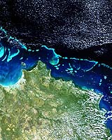
Frascati, Italy (ESA) Oct 04, 2005 Australian researchers have found Envisat's MERIS sensor can detect coral bleaching down to ten metres deep. This means Envisat could potentially monitor impacted coral reefs worldwide on a twice-weekly basis. Coral bleaching happens when symbiotic algae living in symbiosis with living coral polyps (and providing them their distinctive colours) are expelled. The whitening coral may die with subsequent impacts on the reef ecosystem, and thus fisheries, regional tourism and coastal protection. Coral bleaching is linked to sea temperatures above normal summer maxima and to solar radiation. Bleaching may take place on localised and mass scales � there was an extensive bleaching event in 1998 and 2002 likely linked to El Nino events. "An increase in frequency of coral bleaching may be one of the first tangible environmental effects of global warming," states Dr. Arnold Dekker of Australia's Commonwealth Scientific and Industrial Research Organisation�s (CSIRO) Wealth from Oceans Flagship program. "The concern is that coral reefs might pass a critical bleaching threshold beyond which they are unable to regenerate." Aerial or boat-based observation is the current method of detecting bleaching, but many reefs are either inaccessible or simply too large (the Great Barrier Reef has an area of 350 000 square kilometres) for an event that happens within a fortnight. Bleached corals may rapidly be colonised by blue-green to brown algae, more difficult to distinguish from live coral. Repetitive, objective and broad-scale satellite coverage is the alternative. At this week's MERIS/AATSR Workshop in Frascati, Italy, the CSIRO team presented initial results using Envisat's Medium Resolution Imaging Spectrometer (MERIS). MERIS acquires images in 15 different spectral bands at 300 m resolution. "Coral bleaching needs to be mapped at the global scale," Dekker adds. "High-spatial resolution satellites can only do it on a few reefs due to cost and coverage constraints. We need a system that has appropriate coverage and revisit frequency, with a sufficient amount of spectral bands and sensitivity. There is no more suitable system than MERIS." The team studied Heron Island reef at the southern end of the Great Barrier Reef, site of a University of Queensland research station. Validating MERIS Full Resolution mode results, they found that observed changes in live coral cover were correlated to an existing bleaching event. Theoretical studies indicate that for each complete 300-metre pixel of coral under one metre of water it is possible to detect a 2% bleaching of live coral. MERIS should remain sensitive to detecting from 7-8% bleached coral even under ten metres of water. "MERIS Full Resolution covers the world every three days, a bottleneck for global monitoring could be data processing," Dekker concludes. "However satellite sensors measuring sea surface temperature such as Envisat's Advanced Along Track Scanning Radiometer (AATSR) can be applied to prioritise reefs that are subject to sea temperature heating anomalies-thus focusing the MERIS based bleaching detection. Australia's Great Barrier Reef Marine Park Authority has expressed interest in the project. Australian scientists plan to progress to perform MERIS monitoring of bleaching events up to the scale of the whole Great Barrier Reef. Community Email This Article Comment On This Article Related Links CSIRO SpaceDaily Search SpaceDaily Subscribe To SpaceDaily Express Earth Observation News - Suppiliers, Technology and Application
 New York NY (SPX) Jan 11, 2006
The importance of remotely sensed data and technologies to support natural disasters has prompted attention and action in Washington. New initiatives and legislation authorizing appropriations to the remote sensing industry will be discussed at Strategic Research Institute's U.S. Commercial Remote Sensing Industry conference, scheduled for February 9-10, 2006 in Washington D.C. |
|
| The content herein, unless otherwise known to be public domain, are Copyright 1995-2006 - SpaceDaily.AFP and UPI Wire Stories are copyright Agence France-Presse and United Press International. ESA PortalReports are copyright European Space Agency. All NASA sourced material is public domain. Additionalcopyrights may apply in whole or part to other bona fide parties. Advertising does not imply endorsement,agreement or approval of any opinions, statements or information provided by SpaceDaily on any Web page published or hosted by SpaceDaily. Privacy Statement |
