|
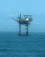
College Station TX (SPX) Sep 16, 2004 In these days when it costs nearly $50 a barrel, spilled oil - unlike milk - could be worth crying about, especially in Texas. A team of Texas A&M University researchers has developed - and continues to refine - a system of buoys in the Gulf of Mexico that can accurately predict the movement of oil spills. Such spills can present Texas-sized problems, both environmentally and economically, to the state's coastline. The buoys can even be used to locate ship passengers who have been lost overboard. Also, two years ago the buoys were instrumental in helping to retrieve the Ehime Maru, a Japanese vessel that was accidentally sunk by a U.S. submarine practicing quick-surfacing drills off the coast of Hawaii. Norman Guinasso Jr., who serves as project manager of the Texas Automated Buoy System (TABS), part of the College of Geosciences' Geochemical and Environmental Research Group (GERG) at Texas A&M, says the buoy system has already saved Texas taxpayers hundreds of thousands of dollars and has served as a model for other universities that are developing similar buoys to detect pollution such as oil spills. "This is the only buoy system of its kind in the Gulf of Mexico and one of the few of its kind in the world," Guinasso says of the TABS project. "The instruments on each buoy can tell us precise information about ocean currents, wind speed, water temperature and other data that allows to accurately predict where a spill is headed and when it will present a problem to the coastline." Each buoy is capable of relaying that information to a constellation of satellites orbiting the Earth, and that information in turn is transferred down to GERG's headquarters in College Station - located about 150 miles from the Texas coast. Information is received by GERG's computers every few hours, 24 hours a day, Guinasso explains, allowing researchers and government agencies to project accurately where a spill is headed. In all, nine buoys are used in the TABS project, stretching from near Sabine Pass on the upper Texas coast down to the border of Mexico near Brownsville, an area covering about 400 miles in length and reaching 100 miles off the coast. The TABS project is coordinated by the Texas General Land Office, which funds much of the $1 million-plus buoy system, and by oil companies who operate in the Gulf of Mexico. Buoys range in size from torpedo-shaped eight-foot long cylinders to circular-shaped ones, each floating on the water's surface. Prices of each range from about $30,000 to $200,000, depending on the sensors installed. A 2-cent-per-barrel tax on all oil transported in Texas waters helps support most of the costs, Guinasso says. The TABS project was put to the test in 1996 shortly after the first buoys were positioned in the Gulf of Mexico. In March of that year, the Buffalo Barge 292 started spilling oil into the Houston Ship Channel and the sludge was quickly blown out to sea by a strong cold front that had moved in from the north. First reports indicated that the oil spill was headed toward a sensitive marine sanctuary at Sabine Pass, but within hours, the TABS system showed the opposite was true - the spill was headed south down the Texas coast, and the result was the saving of at least $250,000 in cleanup costs. "But the important thing is that state officials realized the true value of these buoys," Guinasso says. "We saved the time and effort of mounting a response in areas where it wasn't needed." The buoys are silent sentinels standing watch over the Flower Garden Banks National Marine Sanctuary, the region's only coral reef, located about 90 miles south of Galveston. They warn of impending pollution, such as oil spills from the many oil drilling platforms in the area. All oil companies operating within 40 miles of the Flower Garden Banks are required by law to protect it, Guinasso notes, "so our buoys are something they very much need and want." When the nuclear submarine USS Greeneville collided with the Ehime Maru on Feb. 9, 2001, nine Japanese crewmembers were killed and the ship sank in 2,000 feet of water. The Navy developed plans to raise the sunken ship off the sea bottom and transport it to shallower waters, making recovery operations feasible. But the Navy needed Texas A&M's help. "They wanted to borrow two of the buoys to aide retrieval purposes, especially to measure currents, winds and other data," he recalls. "We received permission from the Texas General Land Office to loan buoys to the Navy for this operation. We then were able to install two buoys one-third of the way around the world on short notice, and the recovery mission was a success." "It's just one example of how valuable and important these buoys can be. They serve the state of Texas very well." Community Email This Article Comment On This Article Related Links GERG at Texas A&M University SpaceDaily Search SpaceDaily Subscribe To SpaceDaily Express Earth Observation News - Suppiliers, Technology and Application
 New York NY (SPX) Jan 11, 2006
The importance of remotely sensed data and technologies to support natural disasters has prompted attention and action in Washington. New initiatives and legislation authorizing appropriations to the remote sensing industry will be discussed at Strategic Research Institute's U.S. Commercial Remote Sensing Industry conference, scheduled for February 9-10, 2006 in Washington D.C. |
|
| The content herein, unless otherwise known to be public domain, are Copyright 1995-2006 - SpaceDaily.AFP and UPI Wire Stories are copyright Agence France-Presse and United Press International. ESA PortalReports are copyright European Space Agency. All NASA sourced material is public domain. Additionalcopyrights may apply in whole or part to other bona fide parties. Advertising does not imply endorsement,agreement or approval of any opinions, statements or information provided by SpaceDaily on any Web page published or hosted by SpaceDaily. Privacy Statement |