|
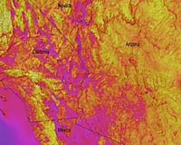
Halifax, Canada (SPX) Apr 08, 2008 Acquiring accurate time- and site-specific solar irradiance data and high resolution solar radiation maps is a challenge for solar power/thermal energy producers, power utilities as well as other industries using solar energy data. Solar radiation maps are predominantly based on interpolation of historic ground station data which often fail to reflect fine spatial variability due to micro climates or local changes in weather patterns. The solar climate is constantly changing, and for on-going operation of utility-scale solar power generation projects it is important to supplement existing historical climatology data with detailed current information on solar resource. This information facilitates the identification of trends in solar power generation capacity and solar power plant's ability to meet basic load and peak power needs, and allows for informed development of pricing and selling strategies for the power generated. Green Power Labs has completed the development of SolarSatData - a unique toolset for high resolution solar resource mapping based on the analysis of current weather satellite data. This technology allows for creating hourly, daily and monthly maps of solar resource and analyzing temporal and spatial variability in solar radiation due to changing weather patterns and climate. The developed proprietary toolset features maps with high temporal and spatial resolution in solar irradiation data. The calculations of solar resource are based on NASA's Geostationary Operational Environmental Satellite (GOES) visible spectrum images which record a portion of the Earth's surface every half hour at spatial resolution of 1 square km. Each of the maps representing monthly average solar radiation is a result of processing of over 720 half-hourly GOES images. The half-hourly maps are also used to evaluate change in solar radiation at every pixel of the map through the day. As a result each 1x1 km pixel of the map represents a "virtual weather station" allowing evaluating both resource availability and reliability of solar energy supply. Green Power Labs' SolarSatData toolset was developed in collaboration with the Applied Geomatics Research Group as a plug-in for ESRI ArcGIS 9.2 software package. Community Email This Article Comment On This Article Related Links All About Solar Energy at SolarDaily.com
 Los Angeles CA (SPX) Apr 08, 2008
SolarHotTub.com, a leading retailer of Do-It-Yourself Solar Hot Tub Kits is pleased to announce anti-freeze prevention with the new wax activated Ogontz freeze valve. The problem with heating water with solar in freeze locations is the chance of trapping water in the panels. Trapped water will freeze and break the solar panels and cause quite a mess. |
|
| The content herein, unless otherwise known to be public domain, are Copyright 1995-2007 - SpaceDaily.AFP and UPI Wire Stories are copyright Agence France-Presse and United Press International. ESA Portal Reports are copyright European Space Agency. All NASA sourced material is public domain. Additional copyrights may apply in whole or part to other bona fide parties. Advertising does not imply endorsement,agreement or approval of any opinions, statements or information provided by SpaceDaily on any Web page published or hosted by SpaceDaily. Privacy Statement |