|
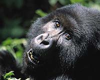
Greenbelt MD (SPX) Jan 11, 2005 Satellites provide a bird's eye view of planet Earth, and the space-based vantage can be extremely useful to people interested in viewing out-of-the-way places. Conservationists, for example, must monitor far-flung areas in need of protection. Wars, poverty, remoteness, lack of government involvement, and uncertainty over the best places and ways to focus limited resources can all hinder conservation efforts. Now, NASA satellite imagery is giving scientists and conservationists some of the tools they need to get valuable information on land cover and land use changes in wild areas. NASA satellite imagery helps scientists better understand land changes in the Virunga Conservation Area which covers the Virunga National Park in the Democratic Republic of Congo (DRC), the Mgahinga Gorilla National Park in Uganda and the Volcanoes National Park in Rwanda. In Swahili, the word virunga means volcano. The Virunga Conservation Area offers habitat to 380 of the world's 700 remaining mountain gorillas. The other 320 gorillas reside in the nearby Bwindi Impenetrable National Park in Uganda. In a single week in June of 2004, farmers created pasture for their cattle by clearing 15 square kilometers (5.8 square miles), or 6 percent, of the 264-square kilometers (102 square miles) of mountain gorilla habitat in the southern "Mikeno" sector of Virunga National Park. Because mountain gorilla numbers had increased by close to 56 individuals over the last 10 years, the recent loss of land was a considerable step backward. In a race against time for the mountain gorillas and many other species indigenous to these natural areas, scientists at the Woods Hole Research Center (WHRC) in Woods Hole, MA, are working with NASA and conservationists in the Virunga National Park to stave off further destruction of the lands. "Remote sensing is the only tool that we have to efficiently monitor these remote parks," says Nadine Laporte, head of the Africa Program at WHRC. "Satellite imagery allows park managers to update park property boundaries, map forest habitat, and look at encroachment of the park by comparing images from two different dates." Laporte is working with conservation groups to create a monitoring system that combines NASA satellite imagery with aerial flight and field surveys, all of which can be relayed to and coordinated with local park rangers on the ground. Currently, park workers are building a three-foot wall along key park borders to keep out cattle and people seeking to alter the land. NASA now provides free Landsat images, which researchers and rangers are using as base maps for field surveys. "We still have to integrate remote sensing with traditional surveys on the ground," said Laporte. "They really complement each other. The rate of change is so rapid that we need satellite imagery in a timely fashion to address the problems in the area. Aerial imagery is too expensive." Since gorilla habitat crosses three different countries, satellite imagery provides data and perspectives that are not bound by political borders. The satellite images can create a convenient method for exchanging information among the three parks that make up the Virunga Conservation Area. Along with mapping and monitoring changes in forest cover, a time-sensitive series of images can allow researchers to estimate rates and patterns of deforestation in and around protected areas. These patterns are also studied in relation to trends in human migration. Community Email This Article Comment On This Article Related Links NASA's Goddard Space Flight Center Woods Hole Research Center SpaceDaily Search SpaceDaily Subscribe To SpaceDaily Express Earth Observation News - Suppiliers, Technology and Application
 New York NY (SPX) Jan 11, 2006
The importance of remotely sensed data and technologies to support natural disasters has prompted attention and action in Washington. New initiatives and legislation authorizing appropriations to the remote sensing industry will be discussed at Strategic Research Institute's U.S. Commercial Remote Sensing Industry conference, scheduled for February 9-10, 2006 in Washington D.C. |
|
| The content herein, unless otherwise known to be public domain, are Copyright 1995-2006 - SpaceDaily.AFP and UPI Wire Stories are copyright Agence France-Presse and United Press International. ESA PortalReports are copyright European Space Agency. All NASA sourced material is public domain. Additionalcopyrights may apply in whole or part to other bona fide parties. Advertising does not imply endorsement,agreement or approval of any opinions, statements or information provided by SpaceDaily on any Web page published or hosted by SpaceDaily. Privacy Statement |