|
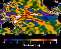
Pasadena - Dec 5, 2001 Researchers at NASA's Jet Propulsion Laboratory, Pasadena, Calif., have conducted groundbreaking research, proving that Global Positioning System altimetry may be an inexpensive, effective tool to measure sea levels. Altimetry uses special instruments that measure height. The findings come from an experiment at Crater Lake in Oregon. It disproved the idea that Global Positioning System signals are too weak to provide accurate sea level measurements. The goal was to first test the technology's capability over a lake, with the eventual goal of testing it over the ocean. A constellation of satellites with Global Positioning System receivers could watch the global sea level rise. "It's shades of things to come," said Dr. Robert Treuhaft, JPL research scientist. "It's a tremendous advancement for the field of Global Positioning System altimetry and the first state-of-the-art result. It has the potential to revolutionize altimetry for oceanography." Monitoring ocean eddies is vital to environmental studies. These whirlpool-like features serve as nutrient-rich environments that foster and transport juvenile plants and fish. Oceanographers also believe that eddies can affect the dispersal of pollution. With satellites covering Earth's surface, the Global Positioning System is capable of receiving continuous high-resolution information on sea level. Within hours, this information could be fed to computer climate ocean models, which could lead to better forecasting. "High resolutions are required to measure ocean eddies," said Dr. Yi Chao, a JPL oceanographer and co-author of the paper. "The high spatial resolution and rapid temporal coverage are crucial for future ocean altimeter missions." From a rocky observing platform one half kilometer (about one third of a mile) above the lake, researchers were able to accurately measure the surface level of Crater Lake to within 2 centimeters (nearly .8 inches). For about 24 hours, researchers recorded both direct and lake-reflected signals from satellites as they rose or set over Crater Lake. By also measuring the transit time of signals reflected off water, NASA researchers measured the height of the water's surface. The Global Positioning System is a Department of Defense controlled navigation system comprised of 28 Earth-orbiting satellites and a network of tracking stations. By measuring the time it takes for signals to travel directly between satellites and receivers, hand-held or in cars, positions of the satellites and receivers can be determined. The cover of the Dec. 1 issue of Geophysical Research Letters will feature a photo of the experiment at Crater Lake from October 1999, with results of the research within. The article is the first peer-reviewed paper on centimeter-level Global Positioning System altimetry. Treuhaft is the lead author of the paper. The research team also includes JPL research scientists and co-authors Drs. Stephen Lowe and Cinzia Zuffada. CommunityEmail This Article Comment On This Article Related Links Additional images of sea level differences - TOPEX Topex Mission SpaceDaily Search SpaceDaily Subscribe To SpaceDaily Express GPS Applications, Technology and Suppliers
 San Jose CA (SPX) Jan 04, 2006
Continuing to drive GPS further into the mainstream market, SiRF Technology Holdings has revealed that its flagship SiRFstarIII GPS technology is at the heart of TomTom's RIDER, a high performance portable navigation system specifically designed for use on motorcycles and scooters. TomTom is a leading provider of personal navigation products and services to the US and European consumer markets. |
|
| The content herein, unless otherwise known to be public domain, are Copyright 1995-2006 - SpaceDaily.AFP and UPI Wire Stories are copyright Agence France-Presse and United Press International. ESA PortalReports are copyright European Space Agency. All NASA sourced material is public domain. Additionalcopyrights may apply in whole or part to other bona fide parties. Advertising does not imply endorsement,agreement or approval of any opinions, statements or information provided by SpaceDaily on any Web page published or hosted by SpaceDaily. Privacy Statement |