|
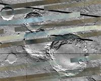
Laurel, MD (SPX) Dec 24, 2007 Scientists are getting a clearer image of mineral distribution on the surface of Mars, thanks to the Compact Reconnaissance Imaging Spectrometer for Mars (CRISM), one of six science instruments on NASA's Mars Reconnaissance Orbiter, currently circling the planet. More than 200 just-released "spectral maps" reveal the distribution of various minerals on the surface of Mars -- the first installment of the Global Mars Map, which will eventually cover the entire planet. The locations and amounts of these minerals provide clues about the geological processes that created different rock formations, and will provide invaluable pointers to when and where liquid water once existed on Mars. These first maps were selected to cover many of the geologically most interesting parts of the planet and represent about 11 percent of Mars' surface. Built and operated by the Johns Hopkins University Applied Physics Laboratory (APL), CRISM detects 544 wavelengths of visible and infrared sunlight reflecting off of the planet's surface. Minerals on the planet absorb some of this sunlight, leaving telltale gaps or absorptions in the spectra of the reflected light. To create the maps, CRISM uses a multispectral survey mode of operation, collecting data from just 13 percent of the available wavelengths to highlight key mineral groups. This lower data-rate mode, coupled with other onboard data compression, decreases the data volume significantly and makes it possible for CRISM to extend its measurements beyond a few thousand targets to cover the entire planet. Each section, or tile, of the Global Mars Map shows a visible-infrared image of a swatch of the planet's surface about 300 kilometers (186 miles) wide, overlaid with 10 kilometer- (6.2 mile-) wide strips of the CRISM spectral data. By creating the map tiles, the CRISM team is providing scientists with a unique tool in the form of uniformly processed data, saving them from the lengthy task of processing the image strips themselves. This initial release of map tiles includes fully calibrated measurements, but without any correction for the obscuring effects of Mars' atmosphere. For the future, we're working on an experimental correction for the atmospheric effects and a series of 'summary' tiles that will capture key information about surface composition," says APL's Scott Murchie, CRISM principal investigator. "We'll continue to add to the Global Mars Map until we've mapped the entire planet, in 1,964 tiles," says Christopher Hash of Applied Coherent Technology, Inc., in Herndon, VA, which is responsible for the specialized software to produce the tiles. Researchers can access the Global Mars Map through NASA's Planetary Data System Geosciences Node. Samples of the tiles can be found under "Featured Images" on the CRISM home page. Community Email This Article Comment On This Article Related Links CRISM Mars News and Information at MarsDaily.com Lunar Dreams and more
 Paris, France (ESA) Dec 21, 2007
ESA, NASA and an international team are developing plans and seeking recommendations to launch the first Mars mission to bring soil samples back to Earth. The ability to study soil from Mars here on Earth will contribute significantly to answering questions about the possibility of life on the Red Planet. |
|
| The content herein, unless otherwise known to be public domain, are Copyright 1995-2007 - SpaceDaily.AFP and UPI Wire Stories are copyright Agence France-Presse and United Press International. ESA Portal Reports are copyright European Space Agency. All NASA sourced material is public domain. Additional copyrights may apply in whole or part to other bona fide parties. Advertising does not imply endorsement,agreement or approval of any opinions, statements or information provided by SpaceDaily on any Web page published or hosted by SpaceDaily. Privacy Statement |