 |
Los Angeles - Sept. 19, 2000 Since March 1999 the Mars Orbiter Laser Altimeter aboard the MGS spacecraft has been sending back data on the topology of Mars. NASA kindly made the data available and in March of this year I started downloading it to create my own 3D model of Mars. The MOLA data consists of height values along each orbit of the MGS spacecraft at roughly 300m intervals. This means that the data density is high in the direction of the orbits but much lower perpendicular to them. First I wrote a program that can produce binary datasets and grayscale maps for a specified area of Mars. It converts the data from its orbital form to a table and uses a bezier curve interpolation algorithm to fill in the gaps. The software can work to any resolution but the higher the resolution the more interpolation and the less accurate the results. The grayscale pictures contained some unnatural lines at first, this was caused by bad orbit data. To remove these lines I enhanced the software so the bad data is automatically detected and filtered out. This was the most difficult part of the project and even now I am not able to remove 100% of the bad data. Next I imported the grayscale maps into Bryce (3D terrain modeling software) and created pictures such as the first one above. I also produced a short movie that simulated flying over Valles Marineris and Olympus Mons. By July I had downloaded more than 10Gb of MOLA data, this consisted of almost 200 Million laser height readings. Each grayscale map or dataset I produced had to process all 10Gb and it was now taking two hours for each run. To overcome this I converted the MOLA datasets from ASCII to a binary format and removed any unnecessary data. This reduced the total size of data to 2Gb and the processing time to 4 minutes. Using compression software I could now fit all the MOLA data (MSGL 1-23) onto 3 CD's. With the software now running so quickly I was able to generate 48 grayscale maps in one evening, each picture had a resolution of 1 pixel to 2.25 km. I also produced an accurate 4000x2000 grayscale map covering the whole surface of Mars.
The data used is an 1890 by 945 table of integers, which gives it a resolution of about 11km. I also wrote a screensaver version of Mars3D and so far this software has been distributed on at least 4 magazine cover disks and featured on several major web sites.
I am an amateur scientist and have done this work in my spare time, all the software and images on my web site are free. Community Email This Article Comment On This Article Related Links Planet 3D New Mars Science at Goddard (five star site) Mars MOLA Site SpaceDaily Search SpaceDaily Subscribe To SpaceDaily Express Mars News and Information at MarsDaily.com Lunar Dreams and more
 Pasadena CA (JPL) Jan 09, 2006
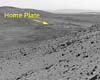
Last week Spirit completed robotic-arm work on "El Dorado." The rover used all three of its spectrometers plus the microscopic imager for readings over the New Year's weekend. |
|
|
|
|
|
|
|
|
|
|
|
|
|
| The content herein, unless otherwise known to be public domain, are Copyright 1995-2006 - SpaceDaily.AFP and UPI Wire Stories are copyright Agence France-Presse and United Press International. ESA PortalReports are copyright European Space Agency. All NASA sourced material is public domain. Additionalcopyrights may apply in whole or part to other bona fide parties. Advertising does not imply endorsement,agreement or approval of any opinions, statements or information provided by SpaceDaily on any Web page published or hosted by SpaceDaily. Privacy Statement |
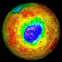 Mars3D (pictured right) took two months to develop and was originally released in May. It allows real-time manipulation via the mouse of an accurate 3D model of Mars. The planet is rendered using color to indicate altitude, a number of color gradients can be selected. The model consists of 3.6 Million triangles and because of this amount of geometry it requires a high powered P.C. to run properly.
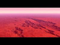
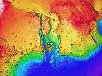 After Mars3D I created Venus3D using the topology data from Magellan and Earth3D using data from NGDC and the GLOBE project. Finally, by applying my software to smaller areas I have created, from screenshots, very high-resolution images of areas such as Kasei Valles, shown right.