|
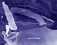
Antarctica (ESA) Oct 23, 2002 A new giant was born recently in the coastal waters of Antarctica. A series of images captured from May through the beginning of this month by ESA's Envisat satellite shows the subsequent duel between the new iceberg and another as it breaks free of the Ross Ice Shelf and tries to move north. Christened C-19 by the US National Ice Centre in Maryland, the new iceberg measured 200 x 32 km, and about 200 m thick. As seen in the accompanying animation of images acquired by Envisat's Advanced Synthetic Aperture Radar (ASAR) from 3 May through 7 October, C-19 jostles for position with an older iceberg, B-15a, resting aground in shallow water off Ross Island. C-19 scrapes along the side of B-15a and, failing to move its firmly anchored adversary, finally heads off into open sea and an eventual demise in warmer waters.
Iceberg "calving" "They can form as a result of the action of wind and waves, or simply because the ice shelf has grown too large to support part of itself," Vaughan explained. "Once in a while, an older iceberg collides into an ice shelf and breaks off a new iceberg." The ASAR imagery also clearly outlines that the C-19 berg is not moving through open water. The white swirls captured in the image represent sea ice, offering more resistance to the movement of the iceberg, but winds and ocean currents finally prove too strong to overcome. Also evident in the radar image is the difference between Antarctic ice that is resting on land or water. The Ross Ice Shelf, for instance, is seen as a smooth surface. To the left-hand side of the images, however, the radar image shows the rougher terrain of Antarctic ice resting on land.
Part of the normal Antarctic ice cycle Since C-19 was already floating before it calved, however, it will not cause any rise in world sea level, according to the British ice expert. In addition, since this ice shelf has shown no progressive retreat in recent years, scientists are expected to view this event as part of the natural lifecycle of the Ross Ice Shelf. "However, if similar events continue to occur then we may begin to believe that this is a result of climate change," Vaughan cautioned. "For the moment, the jury is still out." Envisat's ASAR sensor has several key advantages over optical sensors: it can penetrate cloud cover, which is especially useful in studying polar regions, and can capture imagery at night. ASAR is the first permanent spaceborne radar to incorporate dual-polarisation capabilities -- the instrument can transmit and receive signals in either horizontal or vertical polarisation. This Alternating Polarisation (AP) mode can improve the capability of a SAR instrument to classify different types of terrain. The sensor also can record imagery on-board the spacecraft and the images can be made available a few hours after acquisition. Community Email This Article Comment On This Article Related Links British Antarctic Survey Envisat Results Earth Observation Programme SpaceDaily Search SpaceDaily Subscribe To SpaceDaily Express Dirt, rocks and all the stuff we stand on firmly
 Paris (ESA) Jan 12, 2006
Using the ESA Cluster spacecraft and the NASA Wind and ACE satellites, a team of American and European scientists have discovered the largest jets of particles created between the Earth and the Sun by magnetic reconnection. This result makes the cover of this week's issue of Nature. |
|
| The content herein, unless otherwise known to be public domain, are Copyright 1995-2006 - SpaceDaily.AFP and UPI Wire Stories are copyright Agence France-Presse and United Press International. ESA PortalReports are copyright European Space Agency. All NASA sourced material is public domain. Additionalcopyrights may apply in whole or part to other bona fide parties. Advertising does not imply endorsement,agreement or approval of any opinions, statements or information provided by SpaceDaily on any Web page published or hosted by SpaceDaily. Privacy Statement |