|
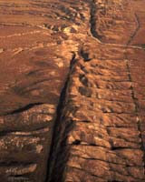
Salt Lake City UT (SPX) Oct 18, 2005 EarthScope, an enormous, nationwide earth science project, is poised to revolutionize understanding of earthquakes, fault systems, volcanoes and the North American continent's structure. But geologists can mine even more information from the project and engage nonscientists of all ages if they take a radically different approach to deciding where to focus attention and funding, said Ben van der Pluijm, a professor of geological sciences at the University of Michigan. Van der Pluijm presented his ideas for such an approach - a concept he calls GeoTraverse - on Oct.16 at a meeting of the Geological Society of America in Salt Lake City, Utah. EarthScope, an NSF-funded project designed to provide a three-dimensional view of the geophysical processes that affect North America, has three main parts. In one part, the San Andreas Fault Observatory at Depth, a borehole is being drilled into the San Andreas Fault, about halfway between Los Angeles and San Francisco. Rock and fluid samples will be taken, and instruments installed in the borehole will create a kind of underground observatory for monitoring how the fault zone changes before, during and after earthquakes. The second part, the Plate Boundary Observatory, is a system of instruments for studying interactions among tectonic plates---the moving blocks of Earth on which the continents reside. The third component of EarthScope, called USArray, will use a mobile system of nearly 3000 scientific instruments. The instruments will move east from California over the next decade, providing 3-D images of structures that lie deep beneath the United States. It is in the USArray project that geologists have an opportunity to work together in unprecedented ways to get the biggest scientific payoff, van der Pluijm said. The core of the project is a transportable array of 400 portable broadband seismometers, to be placed in a grid at intervals of about 70 kilometers (44 miles). But there's also a suite of 2400 instruments for collecting shorter-term seismic recordings, and deciding where to place those instruments is where GeoTraverse comes in. "You can't adequately instrument the whole country; you've got to select certain areas," van der Pluijm said. "Typically that's done through competition. Individuals or small groups of scientists write proposals that compete with other scientists' proposals." The disadvantage is, individual projects are selected in piecemeal fashion, without considering how they relate to one another. Instead, van der Pluijm would like to see groups of geologists identify areas where the instruments could best be used to explore scientifically interesting questions, but select only those areas that can be connected into one or a few east-west transects. For example, a single transect might pass from the active plate margin near Seattle, through Yellowstone National Park, the New Madrid seismic zone - an active fault in the middle Mississippi Valley that could produce devastating earthquakes in years to come - and the southern Appalachians. An alternative to a single transect would be a series of shorter transects that link the most representative assortment of sites. Including geologically interesting National Parks such as Yellowstone in the transect or transects would have an additional benefit, van der Pluijm said. With its truckloads of mobile instruments, EarthScope will attract attention whenever it rolls into a new region. Setting up seismometers in areas the general public is already curious about would offer opportunities to explain "why we do what we do," van der Pluijm said. "People want to know why the Black Hills are where they are or why Yellowstone is the way it is. Why not capitalize on the natural interest and curiosity people have?" Van der Pluijm admits that getting geologists to consider new ways of prioritizing projects will be challenging. But the payoff, he said, "is an outcome greater than the parts alone. In this case, you'll have a cross-continent segment through the crust, across geographically diverse and scientifically interesting areas, that will help us understand not just the individual areas, but also their connections and how they came together. And that, ultimately, will help us understand how our continent came into being," serving one of the primary goals of the EarthScope project. Community Email This Article Comment On This Article Related Links Ben van der Pluijm EarthScope National Science Foundation earth science workshop SpaceDaily Search SpaceDaily Subscribe To SpaceDaily Express Tectonic Science and News
 Hyderabad, India (AFP) Dec 16, 2005
India said Friday it would not share information on earthquakes below a magnitude of six on the Richter scale due to security concerns, drawing criticism from the United Nations. |
|
| The content herein, unless otherwise known to be public domain, are Copyright 1995-2006 - SpaceDaily.AFP and UPI Wire Stories are copyright Agence France-Presse and United Press International. ESA PortalReports are copyright European Space Agency. All NASA sourced material is public domain. Additionalcopyrights may apply in whole or part to other bona fide parties. Advertising does not imply endorsement,agreement or approval of any opinions, statements or information provided by SpaceDaily on any Web page published or hosted by SpaceDaily. Privacy Statement |