 |
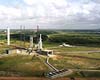
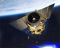
Dulles VA (SPX) Aug 14, 2008 GeoEye has announced that United Launch Alliance (ULA) has initiated a change in the target launch date for GeoEye-1 from August 22 to September 4, 2008. This added time is needed to allow for the positioning of resources to support receipt of down-range telemetry from the Delta II booster vehicle after launch and initial flight from Vandenberg Air Force Base, California. ULA has submitted a request for this revised launch date to the 30th Space Wing. The aircraft for obtaining this support unexpectedly became unavailable, so ULA had to seek an alternative means of capturing this telemetry. ULA has taken the necessary steps and fully expects that this support will be in place for the new planned target launch date of September 4. Bill Schuster, GeoEye's chief operating officer said, "This activity is not related to either our GeoEye-1 satellite or to the booster's readiness. The GeoEye-1 spacecraft has successfully completed all of its pre-launch checkouts prior to being mated to the booster which is now expected to happen the third week of August." The other significant item left to complete this launch is the re-test of a Range Safety antenna on the booster. This re-test is scheduled for completion on August 16. GeoEye-1 remains at the Payload Processing Facility at VAFB ready to be lifted and placed on top of the booster. The launch vehicle is stacked on the pad at Space Launch Complex 2 West. Booster processing continues. The launch time remains at 11:50:57 a.m. (PDT). Boeing Launch Services is supporting the commercial launch of GeoEye-1 and procured the launch vehicle and associated support services from ULA. GeoEye-1 will have the highest resolution of any commercial imaging system -- 0.41-meters or 16 inches for panchromatic (black and white) imagery and multispectral (color) imagery at 1.65-meter resolution. The satellite is designed to offer three-meter accuracy, which means that end users can map natural and man-made features to within three meters of their actual locations on the surface of the Earth without ground control points. GeoEye-1 was financed in part by GeoEye's approximate $500-million contract with the National Geospatial-Intelligence Agency (NGA). Community Email This Article Comment On This Article Share This Article With Planet Earth
Related Links GeoEye-1 launch Launch Pad at Space-Travel.com
 Kourou, French Guiana (SPX) Aug 13, 2008
The fifth heavy-lift Ariane 5 mission of 2008 has been cleared for this week's liftoff with its payload of two international Ku-band telecommunications satellites, maintaining the accelerated pace for Arianespace's workhorse commercial launch vehicle. |
|
| The content herein, unless otherwise known to be public domain, are Copyright 1995-2007 - SpaceDaily.AFP and UPI Wire Stories are copyright Agence France-Presse and United Press International. ESA Portal Reports are copyright European Space Agency. All NASA sourced material is public domain. Additional copyrights may apply in whole or part to other bona fide parties. Advertising does not imply endorsement,agreement or approval of any opinions, statements or information provided by SpaceDaily on any Web page published or hosted by SpaceDaily. Privacy Statement |
 del.icio.us
 Digg
Digg Reddit
 YahooMyWeb
 Google