 |
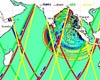
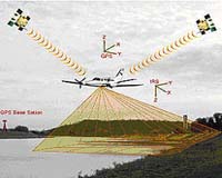
LaJolla, CA (SPX) Jul 17, 2008 All data acquired by the GeoEarthScope Northern California Airborne LiDAR project are now available for download to researchers, engineers, planners, students, and others via the GEON portal at the San Diego Supercomputer Center (SDSC) at UC San Diego. The GeoEarthScope Northern California LiDAR (Light Detection And Ranging) project acquired high resolution topography data starting in spring 2007, along major active geologic faults in the western United States as part of the EarthScope Facility project funded by the National Science Foundation (NSF). Between this project and the previously conducted B4 project in Southern California, also funded by NSF, the entire San Andreas fault system and associated geologic features have now been mapped with high-resolution airborne LiDAR. This was the first in a series of large-scale GeoEarthScope LiDAR acquisition projects. Earlier this year, extensive high-resolution LiDAR data for active faults in southern and eastern California and the Pacific Northwest were acquired. Features included in this acquisition include the Garlock and Elsinore faults in California and the Yakima Fold and Thrust Belt in Washington. These data are currently being processed and will be available this fall via the GEON portal, based at the San Diego Supercomputer Center on the UC San Diego campus. The final GeoEarthScope LiDAR field campaign is in progress this month, with the goal of acquiring data for features in Yellowstone National Park, the Tetons, the Wasatch Front and Alaska. "Providing online access to large scientific data sets, along with rich data processing, analysis, and visualization services, is the direction for the future, as much of science becomes data intensive in nature and dominated by the need for high-performance data processing," said Chaitan Baru, principal investigator for the GEON. "The GeoEarthScope LiDAR data provide an unprecedented representation of the topography along many active faults in the western United States and will be a phenomenal resource for researchers studying earthquake hazards, faulting, and tectonics in that region," said Christopher Crosby, manager of the GEON LiDAR project at SDSC. "The GEON LiDAR system utilizes cyberinfrastructure capabilities developed at SDSC to provide internet-based access and processing of these massive and computationally challenging datasets to a large and diverse scientific user community." GeoEarthScope, a component of the NSF-funded EarthScope project, includes the acquisition of aerial and satellite imagery and geochronology. It is managed by UNAVCO, a non-profit, membership-governed consortium that supports Earth science by advancing high-precision techniques for the measurement and understanding of crustal deformation. GeoEarthScope is conducted in partnership with the U.S. Geological Survey (USGS) and the National Aeronautics and Space Administration (NASA). Community Email This Article Comment On This Article Share This Article With Planet Earth
Related Links GEON web site University of California, San Diego Earth Observation News - Suppiliers, Technology and Application
 Pasadena CA (JPL) Jul 17, 2008
For humans in the path of destructive hurricanes and tsunamis, an accurate warning of the pending event is critical for damage control and survival. Such warnings, however, require a solid base of scientific observations, and a new satellite is ready for the job. |
|
| The content herein, unless otherwise known to be public domain, are Copyright 1995-2007 - SpaceDaily.AFP and UPI Wire Stories are copyright Agence France-Presse and United Press International. ESA Portal Reports are copyright European Space Agency. All NASA sourced material is public domain. Additional copyrights may apply in whole or part to other bona fide parties. Advertising does not imply endorsement,agreement or approval of any opinions, statements or information provided by SpaceDaily on any Web page published or hosted by SpaceDaily. Privacy Statement |
 del.icio.us
 Digg
Digg Reddit
 YahooMyWeb
 Google