|
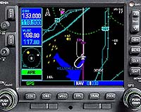
Olathe KS (SPX) Dec 06, 2004 Garmin announced last Thursday that the company has received FAA certification to add TSO C151b Class-B Terrain Awareness and Warning System (TAWS) functionality to the GNS 530 and GPS 500. This certification enables the Garmin 500 series of panel-mount avionics to provide the pilot with graphical and audible alerts of potential terrain and obstacle conflicts along the flight path. "TAWS technology represents a significant advance in flight safety and its widespread adoption could dramatically reduce the number of terrain-related accidents - one of the leading causes of fatalities in aviation," said Gary Kelley, Garmin's director of marketing. "Not only does Garmin's TAWS certification for the GNS 530 and GPS 500 help owners of turbine-powered aircraft meet an important FAA mandate, but it also makes TAWS functionality affordable to thousands of single- and twin-engine piston aircraft owners at a fraction of the cost of other systems." The addition of TAWS enables the GNS 530 and GPS 500 to graphically display the surrounding terrain and obstacles in bright yellow and red, relative to the aircraft's current altitude. Yellow is used to depict conflicts 1,000 to 100 vertical feet below the aircraft. Red is used to depict conflicts 100 vertical feet below the aircraft's current altitude and above. Working in tandem with the aircraft's audio system, the TAWS-certified GNS 530 and GPS 500 provide audible cautions and warnings to alert the pilot of a possible terrain and obstacle conflict. Audible and graphical alerts include forward-looking terrain avoidance, imminent terrain impact, premature descent during approach, altitude loss after takeoff, 500-foot callout and excessive rate of descent. The FAA is requiring that all U.S.-registered, turbine-powered aircraft with six or more passenger seats be equipped with certified TAWS technology by the end of March 2005. The GNS 530 is an integrated system with IFR oceanic-approved GPS, VHF navigation with instrument landing system, and VHF communication with 8.33-kHz channel spacing. Its five-inch (diagonal) color TFT display features an electronic map with a built-in database of cities, highways, rivers, lakes and coastlines, as well as a complete Jeppesen database. Further, it is designed to interface with traffic-avoidance, lightning-detection and weather-datalink systems like a multi-function display (MFD). The GPS 500 is an IFR oceanic- approved GPS navigation system with a five-inch, color moving-map display. Like the GNS 530, it also has MFD-like attributes. The TAWS-certified GNS 530 and GPS 500 systems are now available starting at $24,995 and $20,500 (MSRP), respectively. Garmin also offers a TAWS upgrade program for current owners of GNS 530 and GPS 500 systems. The program requires owners to contact their Garmin distributor, who will send the equipment to Garmin's overhaul facilities in the U.S. and U.K., where the TAWS upgrade will be performed. The cost of this upgrade is $8,000. Community Email This Article Comment On This Article Related Links Garmin SpaceDaily Search SpaceDaily Subscribe To SpaceDaily Express GPS Applications, Technology and Suppliers
 Cheltenham, England (SPX) Jan 09, 2006
Marotta UK is pleased to announce that it designed, developed and qualified equipment for the cold gas propulsion systems on board the Galileo GIOVE-A, part of Europe's Galileo navigation program, successfully launched by Surrey Satellite Technology (SSTL). |
|
| The content herein, unless otherwise known to be public domain, are Copyright 1995-2006 - SpaceDaily.AFP and UPI Wire Stories are copyright Agence France-Presse and United Press International. ESA PortalReports are copyright European Space Agency. All NASA sourced material is public domain. Additionalcopyrights may apply in whole or part to other bona fide parties. Advertising does not imply endorsement,agreement or approval of any opinions, statements or information provided by SpaceDaily on any Web page published or hosted by SpaceDaily. Privacy Statement |