|
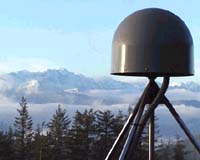
Newcastle - Nov 12, 2002 Scientists' understanding of the movement of the Earth's crust is being helped by a new, highly accurate observing facility which is taking measurements that may one day help predict earthquakes. Newcastle University has become the north westerly centre in Europe and one of just two UK sites feeding Global Positioning System (GPS) data into the International GPS Service (IGS), which researchers and professionals throughout the world -- including geophysicists -- can access via the Internet. The other centre is the Royal Greenwich Observatory in Herstmonceux, East Sussex. The data is collected via a GPS station 20 miles north of the city, at the University's farm, Cockle Park, in Morpeth, Northumberland, which had to meet stringent IGS standards. The distances between a circular antenna and and the GPS satellites above are measured every 15 seconds. The antenna, which is 40cm across and 15cm high, is firmly fixed in a 4.5 tonne slab of 300 million year old sandstone from Yorkshire, which is in turn embedded almost three metres into the earth. The information is automatically downloaded hourly into a computer which quickly checks the data for accuracy before transmitting it to the IGS. Over 200 sites across the world are transmitting data on a regular basis. The antenna gives more accurate measurements than the average GPS system because it is very stable, being firmly embedded into the earth. It will be able to gauge movements in the Earth's crust in the North East of England, as when the Earth moves, the antenna moves with it -- causing the measurements between it and the satellites to alter. The highly accurate data could also help weather forecasts for the North East. Distances between the antenna and the GPS satellites appear longer when there is water vapour in the atmosphere, as it can take a greater period of time for signals to be transmitted. These measurements can be used to compile weather forecasts. Surveyors and other professionals taking less accurate GPS measurements in the field are likely to use this as a reference point against which they can check their own data. It is already being used in a number of university research projects involving GPS, such as the monitoring of North Sea oil platform subsidence. Researcher Matt King, from the University's School of Civil Engineering and Geosciences, which is responsible for the GPS site, said: "The recent earthquakes in Manchester and Italy have highlighted our need to better understand the movement of the Earth's crust in England. Experience in California has shown that GPS measurements can make a valuable contribution to this understanding. "The near real-time transmission of the data may also mean better weather forecasts for the region." Dr King added: "The data submitted to the IGS is used to define the fundamental reference frame on which all modern survey measurements are based. Consequently, anyone making use of surveying or mapping products, such as Ordnance Survey maps, will benefit from this new project." Community Email This Article Comment On This Article Related Links International GPS Service University of Newcastle upon Tyne SpaceDaily Search SpaceDaily Subscribe To SpaceDaily Express Tectonic Science and News
 Sydney (AFP) Dec 12, 2005
Thousands of tonnes of ash are continuing to spew from a volcano in Vanuatu, but officials said Monday the activity on the South Pacific nation was not likely to result in a major deadly eruption. |
|
| The content herein, unless otherwise known to be public domain, are Copyright 1995-2006 - SpaceDaily.AFP and UPI Wire Stories are copyright Agence France-Presse and United Press International. ESA PortalReports are copyright European Space Agency. All NASA sourced material is public domain. Additionalcopyrights may apply in whole or part to other bona fide parties. Advertising does not imply endorsement,agreement or approval of any opinions, statements or information provided by SpaceDaily on any Web page published or hosted by SpaceDaily. Privacy Statement |