|
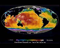
Pasadena - Sep 19, 2002 Just as sunlight glints off the ocean's surface, so do radio signals from the constellation of global positioning system (GPS) navigation satellites orbiting Earth. Now, researchers from NASA's Jet Propulsion Laboratory, Pasadena, Calif., have shown that although these reflected signals are very weak, they can be detected by airborne instruments and used to map ocean eddies. Eddies, which affect shoreline weather and the fishing industry, represent "one of the largest unknowns in Earth's climate models," said JPL physicist Dr. Stephen Lowe. Lowe led two aircraft experiments to test how well GPS could be used for altimetry, or measuring sea-surface height. Eddies are currents that run in a circular path against the main flow of current. Warm eddies have a higher surface height than the surrounding water, while cool eddies are lower. Ranging from 10 to 100 kilometers (6 to 62 miles) in size, many ocean eddies are either too small or don't last long enough to be spotted by the current generation of satellite ocean altimeters, whose measurements of sea-surface height provide a picture of global circulation. Lowe and his colleagues' goal is to determine whether, in the future, reflected GPS signals could be used to map small ocean circulation features such as eddies from space. "Eddies are small features with a big impact," said co-author Dr. Yi Chao, a JPL oceanographer. "They're where a lot of ocean physics happens and are an integral part of our climate system. But we don't have enough information about them to include in our models. "Coastal eddies also have a major role in regulating the weather near the shore, and they are important for fisheries because they're where fish go to feed. In the open ocean, eddies bring nutrient-rich cold water up to the surface and are an important part of the global carbon cycle." In the first experiment, designed to collect reflected GPS signals from a variety of terrain, the scientists demonstrated that these signals could be detected and used to calculate ocean height. In the second experiment, planned specifically for ocean altimetry, they showed their technique has the potential to provide ocean-height measurements precise enough to map ocean eddies. The results of the latest experiment appear in the May issue of Geophysical Research Letters. Today's satellite ocean altimeters, including the US-French Topex/Poseiden and Jason 1 spacecraft, measure sea-surface height by sending a radar pulse to the ocean's surface and timing its return. While they measure ocean surface topography very accurately, to within 2 centimeters (1 inch), they see only the swath of ocean directly beneath them and take 10 days to make a complete map of the global ocean. Since an ocean eddy lasts only a week or two, they may only catch a portion of an eddy's lifespan. In contrast, an orbiting GPS altimeter would have no radar, making it relatively inexpensive. The receiver would obtain position and timing information from the GPS constellation of satellites and would measure ocean height using the arrival time of GPS signals reflected from the surface. At any single time, it would be able to produce about 10 simultaneous measurements across an area thousands of kilometers wide. A constellation of about 10 such instruments, capable of making up to 100 simultaneous ocean-height measurements, could map ocean eddies globally. The Global Positioning System is a Department of Defense-controlled navigation system comprised of 28 Earth-orbiting satellites and a network of tracking stations. By measuring the time it takes for signals to travel directly between satellites and receivers, the positions of the satellites and receivers can be determined. In coming experiments, the JPL researchers will fly their equipment on aircraft at different altitudes and speeds. They'll be making ocean-height measurements and comparing their results with those from other instruments. They also have plans to improve their onboard receiver so that the instrument can be flown on spacecraft. "Our plan is not to replicate the very precise measurements that Topex/Poseidon and Jason 1 make," said Chao, "but rather to help fill in some of the gaps in time and in coverage by looking between the satellites' ground tracks and close to the shore. We would like to provide a new data set to push the next generation of climate models." Community Email This Article Comment On This Article Related Links More about TOPEX/Poseidon and Jason SpaceDaily Search SpaceDaily Subscribe To SpaceDaily Express Dirt, rocks and all the stuff we stand on firmly
 Paris (ESA) Jan 12, 2006
Using the ESA Cluster spacecraft and the NASA Wind and ACE satellites, a team of American and European scientists have discovered the largest jets of particles created between the Earth and the Sun by magnetic reconnection. This result makes the cover of this week's issue of Nature. |
|
| The content herein, unless otherwise known to be public domain, are Copyright 1995-2006 - SpaceDaily.AFP and UPI Wire Stories are copyright Agence France-Presse and United Press International. ESA PortalReports are copyright European Space Agency. All NASA sourced material is public domain. Additionalcopyrights may apply in whole or part to other bona fide parties. Advertising does not imply endorsement,agreement or approval of any opinions, statements or information provided by SpaceDaily on any Web page published or hosted by SpaceDaily. Privacy Statement |