|
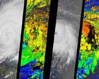
Pasadena CA (JPL) Sep 15, 2004 Seen through the eyes of the Multi-angle Imaging SpectroRadiometer aboard NASA's Terra satellite, the menacing clouds of Hurricanes Frances and Ivan provide a wealth of information that can help improve hurricane forecasts. The ability of forecasters to predict the intensity and amount of rainfall associated with hurricanes still requires improvement, particularly on the 24- to 48-hour timescales vital for disaster planning. Scientists need to better understand the complex interactions that lead to hurricane intensification and dissipation, and the various physical processes that affect hurricane intensity and rainfall distributions. Because uncertainties in representing hurricane cloud processes still exist, it is vital that model findings be evaluated against actual hurricane observations whenever possible. Two-dimensional maps of cloud heights such as those provided by the Multi-angle Imaging SpectroRadiometer offer an unprecedented opportunity for comparing simulated cloud fields against actual hurricane observations. The newly released images of Hurricanes Frances and Ivan were acquired Sept. 4 and Sept. 5, 2004, respectively, when Frances' eye sat just off the coast of eastern Florida and Ivan was heading toward the central and western Caribbean. They are available at: http://photojournal.jpl.nasa.gov/catalog/PIA04367. The left-hand panel in each image pair is a natural-color view from the instrument's nadir camera. The right-hand panels are computer-generated cloud-top height retrievals produced by comparing the features of images acquired at different view angles. When these images were acquired, clouds within Frances and Ivan had attained altitudes of 15 and 16 kilometers (9.3 and 9.9 miles) above sea level, respectively. The instrument is one of several Earth-observing experiments aboard Terra, launched in December 1999. The instrument acquires images of Earth at nine angles simultaneously, using nine separate cameras pointed forward, downward and backward along its flight path. It observes the daylit Earth continuously and every 9 days views the entire globe between 82 degrees north and 82 degrees south latitude. It was built and is managed by NASA's Jet Propulsion Laboratory, Pasadena, Calif. JPL is a division of the California Institute of Technology in Pasadena. Community Email This Article Comment On This Article Related Links MISR at JPL SpaceDaily Search SpaceDaily Subscribe To SpaceDaily Express Earth Observation News - Suppiliers, Technology and Application
 New York NY (SPX) Jan 11, 2006
The importance of remotely sensed data and technologies to support natural disasters has prompted attention and action in Washington. New initiatives and legislation authorizing appropriations to the remote sensing industry will be discussed at Strategic Research Institute's U.S. Commercial Remote Sensing Industry conference, scheduled for February 9-10, 2006 in Washington D.C. |
|
| The content herein, unless otherwise known to be public domain, are Copyright 1995-2006 - SpaceDaily.AFP and UPI Wire Stories are copyright Agence France-Presse and United Press International. ESA PortalReports are copyright European Space Agency. All NASA sourced material is public domain. Additionalcopyrights may apply in whole or part to other bona fide parties. Advertising does not imply endorsement,agreement or approval of any opinions, statements or information provided by SpaceDaily on any Web page published or hosted by SpaceDaily. Privacy Statement |