|
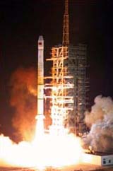
Hong Kong - Nov. 22, 2000 China's newly launched, and the first, navigation positioning satellite Beidou Navigation Test Satellite-1 (BNTS-1; "Beidou" means "Northern Dipper", a reference to the celestial constellation) was reported to be functioning nominally, Wen Wei Po said two weeks ago. However, China has not officially released any details of the satellite and its orbit. Since the initial Xinhua dispatch announcing the launch, little information was available on the mission. A Changzheng-3A (Long March-3A) rocket sent BNTS-1 into space from the Xichang Satellite Launching Center (XSLC) in the southwest Sichuan Province at 2 minutes past midnight on October 31 Beijing Time (16:02 UTC October 30). The day after the launch, Guizhou Du Shi Bao (Guizhou City Post) reported that debris from the first stage of CZ-3A landed in Gaoping Town in the Fuquan Impact Zone. The zone is in the central part of Guizhou Province, some 550 km downrange ESE of the launch centre. A XSLC debris detection team, which stationed in the Guizhou provincial capital Guiyang City, located the impact area 13 minutes after the launch. About two hours later the team arrived at the scene to secure the site and began recovery of the flight data recorder. Twenty-seven minutes after the liftoff, CZ-3A delivered BNTS-1 to an elliptical orbit of 196 x 41890 km and an inclination of 25 deg, according to information obtained from the Orbital Information Group (OIG) database at NASA Goddard Space Flight Center. The satellite remained in that orbit for many days until orbital manoeuvers transferred it to the final geostationary orbit. As of yesterday (Nov. 20) OIG information indicates that the BNTS-1 orbit is 35773 x 35800 km with an inclination of 0.2 deg and a period of 1,436.1 min. (i.e. one rotation of the Earth). The satellite is stationed over the Equator at 140 deg E. longitude. The Xi'an Satellite Control Centre (XSCC) in the central Shaanxi Province conducted the manoeuvers and subsequent operation and testing of the satellite, using a new operation philosophy. In the traditional mode of split operation, XSCC planned the entire tracking program and the tracking station executed the program by issuing commands to the space vehicle. As part of modernizing the operation, XSCC is using a new, transparent "centralized remote control" mode to command BNTS-1. Commands are now issued to the orbiting vehicle directly from the control centre. XSCC says that the centralized operation "strengthens the spacecraft command capability of the centre, particularly in increasing the capability of securing the spacecraft in a contingency." Wen Wei Po quoted an official that BNTS-1 "was working nominally and achieved previously set objectives". The official also said that China would launch more positioning and navigation satellites similar to BNTS-1 in the next few years in order to complete the Beidou satellite navigation and positioning system. Space experts in China said that although BNTS-1 was experimental, it could provide regional navigation and positioning service. However, more satellites would be needed to form a system and provide better and higher precision service globally. The Taiwan newspaper China Times alleged in the Nov. 1 edition that BNTS-1 belonged to the "military navigation satellite twin-satellite series" plan. The first pair of navsats was supposed to be launched this year. At least four of such navsats would be launched to provide high precision positioning to operations on land and in sea. In China, the military value of a satellite navigation and positioning system is recognized. The unnamed official told Wen Wei Po: "In military [operations], navigation of fighter planes and warships and launching of missiles would not leave out using satellite navigation technologies. The successful launch of BNTS-1 earned China a place in the field of satellite navigation and raised the prospects of providing services in various areas very soon." Community Email This Article Comment On This Article Related Links SpaceDaily Search SpaceDaily Subscribe To SpaceDaily Express The Chinese Space Program - News, Policy and Technology China News from SinoDaily.com
 Beijing (XNA) Jan 05, 2006
A one-year lunar fly-by mission may start in April 2007 in China, but a manned flight to the Earth's neighbour may be a long way away, a chief lunar exploration scientist said last night. |
|
|
|
|
|
|
|
|
|
|
|
|
|
| The content herein, unless otherwise known to be public domain, are Copyright 1995-2006 - SpaceDaily.AFP and UPI Wire Stories are copyright Agence France-Presse and United Press International. ESA PortalReports are copyright European Space Agency. All NASA sourced material is public domain. Additionalcopyrights may apply in whole or part to other bona fide parties. Advertising does not imply endorsement,agreement or approval of any opinions, statements or information provided by SpaceDaily on any Web page published or hosted by SpaceDaily. Privacy Statement |