|
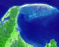
Greenbelt MD (SPX) Aug 17, 2005 On the northern tip of New Zealand's South Island, Farewell Spit stretches 30 kilometers eastward into the Tasman Sea from the Cape Farewell mainland. A sandy beach faces the open waters of the Tasman Sea, while an intricate wetland ecosystem faces south toward Golden Bay. On the southern side, the spit is protected by several kilometers of mudflats, which are alternately exposed and inundated with the tidal rhythms of the ocean. The wetlands of Farewell Spit are on the Ramsar List of Wetlands of International Significance. This image from the Advanced Spaceborne Thermal Emission and Reflection Radiometer (ASTER) on NASA's Terra satellite shows Cape Farewell (left) and Farewell Spit. The sandy dunes on the north side of the spit give way to green vegetation along the southern perimeters. The image captured a great amount of detail of the submerged tidal flats, which appear in shades of bluish-purple. The flats are etched with many channels, giving the flats the appearance of underwater mountains and canyons. Near the shore, the blue-purple color of the flats is tinged with green (see high-resolution image), suggesting the area is home to aquatic plants that can tolerate daily flooding. More than 80 species of wetland birds have been observed at Farewell Spit. Among them are numerous species of migratory shorebirds traveling the East Asia-Australasia flyway. Some birds arrive for the summer, while others fly in for the winter. According to the New Zealand Department of Conservation, the tidal mudflats on Farewell Spit are also an important molting (feather shedding and replacement) site for 12,000 black swans. Community Email This Article Comment On This Article Related Links SpaceDaily Search SpaceDaily Subscribe To SpaceDaily Express Earth Observation News - Suppiliers, Technology and Application
 New York NY (SPX) Jan 11, 2006
The importance of remotely sensed data and technologies to support natural disasters has prompted attention and action in Washington. New initiatives and legislation authorizing appropriations to the remote sensing industry will be discussed at Strategic Research Institute's U.S. Commercial Remote Sensing Industry conference, scheduled for February 9-10, 2006 in Washington D.C. |
|
| The content herein, unless otherwise known to be public domain, are Copyright 1995-2006 - SpaceDaily.AFP and UPI Wire Stories are copyright Agence France-Presse and United Press International. ESA PortalReports are copyright European Space Agency. All NASA sourced material is public domain. Additionalcopyrights may apply in whole or part to other bona fide parties. Advertising does not imply endorsement,agreement or approval of any opinions, statements or information provided by SpaceDaily on any Web page published or hosted by SpaceDaily. Privacy Statement |