|
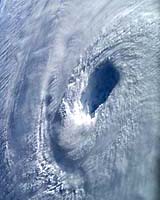
Greenbelt MD (SPX) Sep 08, 2004 Following on the heels of Hurricane Charley, Frances slammed into Florida this weekend, wreaking further havoc on an already battered coastline. Though most would prefer to forget, the public was reminded of a very similar event that occurred close to this time last year. September 18th will mark the one year anniversary of Hurricane Isabel's landfall. Isabel and Frances started off looking so similar, they could have been twins. They both were large and powerful, they both originated in Africa and traveled along the same path across the Atlantic until reaching Antilles near the Caribean. Isabel turned further north than Frances did. Its not a surprise that Frances occurred very close to the one year anniversary of Isabel. Both of these massive storms required summer temperatures to heat up the ocean surfaces to 82 'F to fuel these hurricanes. When Isabel arrived in North Carolina on September 18th, she made a name for herself, by packing hurricane force winds as she came ashore. Now, after almost a year after studying information gathered by satellites, airplanes, buoys, ships and computer models gathered during Isabel's journey, scientists have a unique insight into her life. Hurricane Isabel was a long-lived Cape Verde hurricane that reached Category 5 status on the Saffir-Simpson Hurricane Scale with maximum sustained winds of 166 mph at sea. It made landfall on North Carolina's Outer Banks as a Category 2 hurricane with sustained winds between 97-103 mph. Isabel was one of the most significant tropical cyclones to affect portions of northeastern N.C. and east-central Va. since 1954's Hurricane Hazel. NASA and National Oceanic and Atmospheric Administration (NOAA) satellites monitored Isabel's track, wind intensity, precipitation, and temperature inside the storm using multiple sensors on a number of earth-observing satellites simultaneously. NASA satellite data was provided to NOAA, who provided the watches and warnings to the public. NASA's Seawinds instrument on QuikScat satellite looked at Isabel's wind speed and direction. NASA and the Japanese Meteorological Agency's Tropical Rainfall Measuring Mission (TRMM) satellite kept a close eye on Isabel's clouds and rainfall to see if she was getting stronger or weaker. NASA's Aqua and TRMM satellites looked through the clouds at sea surface temperatures. Sea surface waters warmer than 82 degrees (F) can make hurricanes stronger. Scientists also looked at the heights of the sea to determine Isabel's change in strength using the Jason-1 satellite. NOAA's GOES East satellite provided images as forecasters matched where she was going both day and night to where the computer models projected she would go. The U.S. Department of Defense also provided data from the Defense Meteorological Satellite Program (DMSP) satellite. Closer to Earth aircraft kept a closer eye on Isabel, dropping sensors into the storm to get readings on temperature, humidity and pressure. The 53rd Weather Reconnaissance Squadron of the U.S. Air Force Reserve Command, the NOAA Aircraft Operations Center, and a Canadian research aircraft all observed Isabel. At the Earth's surface, scientists constantly gathered information from ships, land stations, and buoys. In addition to using satellites, several computer models were used. NOAA's Tropical Analysis and Forecast Branch (TAFB), NOAA's Satellite Analysis Branch (SAB) and the U. S. Air Force Weather Agency (AFWA) estimated storm intensity. At NOAA's National Hurricane Center several computer models were run and interpreted by forecasters, resulting in hurricane advisories throughout Isabel's life. Hurricane conditions affected portions of eastern N.C, and southeastern Va. Rainfall averaged 4-7 inches over large portions of eastern N.C., east-central Va. and Md. Rainfall totals of 8-12 inches with locally higher amounts occurred in the Shenandoah Valley in northern Va. Storm surges were 6-8 feet above normal tide levels near the point of landfall along the N.C. coast and in the upper reaches of the Chesapeake Bay near Annapolis and Baltimore, Md. Isabel was directly responsible for 16 deaths along the U.S. east coast. Isabel was just under one month old when she reached the end of her life. On September 20, she became "extra tropical" developing characteristics like storms outside the tropics, and moved northward into Canada. Once in Canada, Isabel was absorbed into another weather system. She left behind her a trail of property damages up to $3.37 billion in her wake through the U.S., with a minimal loss of life as a result of improved technology and forecasts. Community Email This Article Comment On This Article Related Links SpaceDaily Search SpaceDaily Subscribe To SpaceDaily Express Earth Observation News - Suppiliers, Technology and Application
 New York NY (SPX) Jan 11, 2006
The importance of remotely sensed data and technologies to support natural disasters has prompted attention and action in Washington. New initiatives and legislation authorizing appropriations to the remote sensing industry will be discussed at Strategic Research Institute's U.S. Commercial Remote Sensing Industry conference, scheduled for February 9-10, 2006 in Washington D.C. |
|
| The content herein, unless otherwise known to be public domain, are Copyright 1995-2006 - SpaceDaily.AFP and UPI Wire Stories are copyright Agence France-Presse and United Press International. ESA PortalReports are copyright European Space Agency. All NASA sourced material is public domain. Additionalcopyrights may apply in whole or part to other bona fide parties. Advertising does not imply endorsement,agreement or approval of any opinions, statements or information provided by SpaceDaily on any Web page published or hosted by SpaceDaily. Privacy Statement |