|
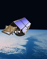
Moscow (SPX) Sep 01, 2005 The European satellite CryoSat, to be brought to the Plesetsk spaceport in the next few days, will measure the ice depth in the Antarctic and Greenland. "The European satellite will be brought by train from Arkhangelsk to Plesetsk," chief press officer of the Russian Space Troops Col. Alexei Kuznetsov told Itar-Tass on Wednesday. "Then the preparation of the satellite CryoSat for launch will begin. The satellite will be launched by the conversion booster Rokot. A team of the Space Troops will launch the satellite," Kuznetsov emphasized. "The satellite will be put on a 720-kilometer-high polar orbit. From this orbit the satellite will make high-precision measurements of the depth and the length of the ice crust in the Antarctic, Greenland, Iceland, Polar ocean areas and highland glaciers," Kuznetsov said. "The equipment onboard the satellite will monitor changes in world ocean levels for three years," he remarked. The designing of the satellite CryoSat was launched in February 2002 after the European Space Agency (ESA) and the company EADS Astrium that is the leading European designer and producer of spacecraft had signed a contract. CryoSat will be the first satellite launched under ESA's Living Planet programme established in 1998. Twelve distant earth probing projects are planned to be implemented under the programme. "CryoSat is expected to be launched on October 8," a source in the Federal Space Agency told Itar-Tass. Community Email This Article Comment On This Article Related Links SpaceDaily Search SpaceDaily Subscribe To SpaceDaily Express Earth Observation News - Suppiliers, Technology and Application
 New York NY (SPX) Jan 11, 2006
The importance of remotely sensed data and technologies to support natural disasters has prompted attention and action in Washington. New initiatives and legislation authorizing appropriations to the remote sensing industry will be discussed at Strategic Research Institute's U.S. Commercial Remote Sensing Industry conference, scheduled for February 9-10, 2006 in Washington D.C. |
|
| The content herein, unless otherwise known to be public domain, are Copyright 1995-2006 - SpaceDaily.AFP and UPI Wire Stories are copyright Agence France-Presse and United Press International. ESA PortalReports are copyright European Space Agency. All NASA sourced material is public domain. Additionalcopyrights may apply in whole or part to other bona fide parties. Advertising does not imply endorsement,agreement or approval of any opinions, statements or information provided by SpaceDaily on any Web page published or hosted by SpaceDaily. Privacy Statement |