|
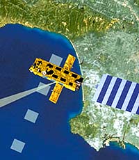
Montreux, Switzerland (AFP) Apr 27, 2007 Eight hundred kilometres above the earth's surface, a huge European satellite that tracks greenhouse gas emissions, melting ice packs and rising sea levels is receiving a new lease of life. The European Space Agency's environmental satellite, Envisat, was launched in 2002 with an expected lifespan of five years, but its mission is turning out to be ever more pertinent amid heightened concern about climate change. The eight tonne, ten-meter (33-foot) long module and its 10 data-collecting instruments, have also proved to be so reliable that it will now carry on for another five to seven years, said mission director Henri Laur. More than 900 scientists gathered in the Swiss lakeside town of Montreux this week for an ESA conference on satellite observation of the world's land, oceans, ice and atmosphere, which also marked Envisat's fifth anniversary. The 250 gigabytes of data the satellite beams to earth every day has allowed them to literally map out changes in levels of pollutants from industry or transport or even to spot oil tankers that illicitly clean out their tanks on the high seas. "You can see the impact of economic change on the environment," Laur said. "Emissions have remained stable in Europe and the United States but have increased sharply in China," he explained. A spectometrer on the satellite can measure levels of carbon dioxide and methane -- two of the main greenhouse gases blamed for climate change -- in the earth's atmosphere. "Our understanding of the phenomenon has benefitted enormously from satellite observations," Laur underlined. "There are many things that we would not have seen otherwise." Envisat, which fits into a network of earth observation satellites, helped determine the speed of the meltdown of glaciers in Greenland, which has doubled in the space of 10 years. It also revealed a three millimetre increase in sea levels, and the extent of the warming of the oceans, according to ESA. Another instrument, a radar altimeter, can measure the rate of thinning of the melting polar icecap, even at night or beneath cloud cover. The 230 technicians at ESA's data processing centre at Frascati, Italy, have also been used to spot deliberate environmental damage by oil tankers venting their tanks. Since oil is heavier than water, the satellite can spot the telltale hyrdocarbon trail because its smoothes the surface waves of the sea. "Envisat is well known to tanker captains," Laur said. "We think that they know our orbit, when we pass overhead," he added. Laur said observations by Envisat helped to reduce illegal fishing off France's Kerguelen Islands in the Indian Ocean by 90 percent. Envisat is likely to be replaced after 2012 by an armada of smaller satellites called "Sentinel", each with a specialised task in observing the chemistry of the earth's atmosphere. However, ESA is still seeking funding from its 17 member states for the broader project, which would allow continued European monitoring of greenhouse gases. Laur said the meeting in Montreux, which ends on Friday, underlined that such monitoring was "very important."
Source: Agence France-Presse Email This Article
Related Links  Fort Collins CO (SPX) Apr 30, 2007
CloudSat, a satellite mission conceived by Colorado State University scientist Graeme Stephens, will celebrate its first anniversary on Saturday as the world's most sensitive cloud-profiling radar in orbit. Since launching 438 miles above Earth on April 28, 2006, CloudSat has made 5,307 orbits around the Earth, snapped 162 million vertical profiles of clouds and distributed more than 6 terabytes of data to the international science community, according to the Cooperative Institute for Research in the Atmosphere, or CIRA, which is based at Colorado State and is responsible for the satellite's data collection. |
|
| The content herein, unless otherwise known to be public domain, are Copyright 1995-2006 - SpaceDaily.AFP and UPI Wire Stories are copyright Agence France-Presse and United Press International. ESA PortalReports are copyright European Space Agency. All NASA sourced material is public domain. Additionalcopyrights may apply in whole or part to other bona fide parties. Advertising does not imply endorsement,agreement or approval of any opinions, statements or information provided by SpaceDaily on any Web page published or hosted by SpaceDaily. Privacy Statement |