|
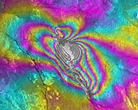
Paris (ESA) Sep 23, 2002 California scientists credit synthetic aperture radar imagery from the European Space Agency with making possible new ways to depict earthquake fault zones and uncovering unusual earthquake-related deformations. Their study of imagery from a 1999 earthquake in the western US could provide a new way to identify active faults and help track when the last earthquake occurred in a fault zone. Writing in last week's issue of Science magazine, researchers from the Scripps Institution of Oceanography at the University of California in San Diego, and the California Institute of Technology detailed their studies of the so-called "Hector Mine" earthquake, a magnitude 7.1 earthquake that tore through 28 miles of faults in the Mojave Desert. Named after a nearby abandoned mine in the remote area, the earthquake caused virtually no damage. It was, however, the "perfect" event to use satellite and radar technologies to document unique characteristics of faults, said Scripps' Yuri Fialko, the study's lead author. The earthquake was comprehensively imaged with interferometric synthetic aperture radar (InSAR), which uses a series of satellite recordings to detect changes in the Earth's surface. The most surprising finding that came out of the analysis of the imagery was the first evidence that faults can move backwards. "Even small stress perturbations from distant earthquakes can cause faults to move a little bit, but it's only been known to cause this motion in a forward sense," Fialko said in a Scripps announcement of the study's publication in Science. "Here we observed the faults coming backwards, due to relatively small stress changes, which is really quite unusual." The article argues that the backward motion on the faults is caused by the dissimilar nature of material within the faults, rather than frictional failure. The results, Failko said, will guide new seismic studies to areas with contrasting fault materials and can then be used to identify potentially active faults. Co-author Peter Shearer of Scripps credited the study's detailed results to the "breakthrough" offered by InSAR technology. "Prior to InSAR, all we had were spot measurements of the deformation field," the Scripps scientist said. "With InSAR we have millions of points and thus a continuous picture of the deformation across southern California." Using the satellite data, the study was able to document both vertical and horizontal terrain displacements of several millimetres to several centimetres across kilometre-wide zones centred on faults. "The findings became possible due to highly successful satellite missions of the European Space Agency," the scientists were cited as saying by the Scripps announcement. In the Science article, the authors pointed out that the earthquake area had been imaged repeatedly by ESA's ERS-1 and ERS-2 satellites over the past 10 years. The research team generated and analysed all possible interferometric pairs that included the earthquake date, ending up with 15 interferograms from a descending orbit, and five interferograms from an ascending orbit. The first synthetic aperture radar was launched in 1991 as one of three main instruments on ESA's ERS-1 satellite. It was followed by a second on ERS-2 in 1995. These highly successful ESA satellites have collected a wealth of valuable data on the Earth's land surfaces, oceans, and polar caps. Today, several hundred research groups worldwide use ERS data to further their studies. With ERS data, the InSAR technique represents a major breakthrough in Earth sciences, allowing scientists to understand better earthquakes and other natural events. Europe's latest environmental satellite, Envisat, was launched earlier this year carrying an advanced SAR (ASAR). Envisat's ASAR instrument is the first permanent spaceborne radar to incorporate dual-polarisation capabilities -- the instrument can transmit and receive signals in either horizontal or vertical polarisation. This dramatically improves the capability of SAR to discriminate between different types of terrain compared with the sensors on the earlier ERS generation of satellites, while offering a continuity of service to users working with the InSAR technique. Community Email This Article Comment On This Article Related Links ERS Envisat Results Scripps Institution of Oceanography Observing the Earth EO Exploitation JPL study on Hector Mine earthquake SpaceDaily Search SpaceDaily Subscribe To SpaceDaily Express Tectonic Science and News
 Sydney (AFP) Dec 12, 2005
Thousands of tonnes of ash are continuing to spew from a volcano in Vanuatu, but officials said Monday the activity on the South Pacific nation was not likely to result in a major deadly eruption. |
|
| The content herein, unless otherwise known to be public domain, are Copyright 1995-2006 - SpaceDaily.AFP and UPI Wire Stories are copyright Agence France-Presse and United Press International. ESA PortalReports are copyright European Space Agency. All NASA sourced material is public domain. Additionalcopyrights may apply in whole or part to other bona fide parties. Advertising does not imply endorsement,agreement or approval of any opinions, statements or information provided by SpaceDaily on any Web page published or hosted by SpaceDaily. Privacy Statement |