|
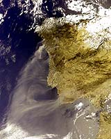
Paris (ESA) Aug 24, 2005 Plumes of smoke from serious wildfires across Portugal fan into the Atlantic in this Envisat satellite view acquired on 21 August. Dozens of wildfires are reported throughout the country, which has suffered one of its worst droughts for decades. Fanned by high winds, the fires have destroyed more than 140 000 hectares of land and killed at least 15 people. Stricken areas include the vicinity of the city of Coimbra, Portugal's third largest city, around 200 km northeast of Lisbon. On the outskirts of the city firefighters are attempting to keep the blazes at bay. Other fires are reported to be burning in the northern districts of Viseu and Viana do Castelo. Firefighting aircraft from France, Germany, Italy and the Netherlands are participating in control activities following an appeal for help by Portugal's government. This international assistance supplements a national firefighting effort of 49 aircraft, around 800 vehicles and 3000 firefighters. The images here come from the Medium Resolution Imaging Spectrometer (MERIS) aboard Envisat, Europe's largest-ever Earth Observation satellite, operating in Reduced Resolution mode for a spatial resolution of 1200 metres. Community Email This Article Comment On This Article Related Links SpaceDaily Search SpaceDaily Subscribe To SpaceDaily Express Earth Observation News - Suppiliers, Technology and Application
 New York NY (SPX) Jan 11, 2006
The importance of remotely sensed data and technologies to support natural disasters has prompted attention and action in Washington. New initiatives and legislation authorizing appropriations to the remote sensing industry will be discussed at Strategic Research Institute's U.S. Commercial Remote Sensing Industry conference, scheduled for February 9-10, 2006 in Washington D.C. |
|
| The content herein, unless otherwise known to be public domain, are Copyright 1995-2006 - SpaceDaily.AFP and UPI Wire Stories are copyright Agence France-Presse and United Press International. ESA PortalReports are copyright European Space Agency. All NASA sourced material is public domain. Additionalcopyrights may apply in whole or part to other bona fide parties. Advertising does not imply endorsement,agreement or approval of any opinions, statements or information provided by SpaceDaily on any Web page published or hosted by SpaceDaily. Privacy Statement |