 |
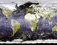
Paris (ESA) Jun 25, 2003 The global reach of the Medium Resolution Imaging Spectrometer (MERIS) instrument on board ESA's Envisat environmental satellite is revealed by this image of our planet Earth as it looked in March 2003. This is a mosaic made up of true colour images using three out of 15 MERIS spectral bands taken from Envisat in polar orbit at an altitude of 800 km, with data combined from around 500 separate orbital segments with the intention of minimising cloud cover as much as possible. The image has a 1.2 km resolution and is made up of 40,000 by 20,000 pixels, equal to 2.5 gigabytes of output data. MERIS records surface reflectivity, and a wide variety of land surface coverings can be discerned in this way, from ice to forest, grassland to desert. This being early spring, much of the Northern hemisphere remains covered in snow and ice, with snows extending far down across Russia. Comparatively small geographical features can be clearly made out, such as the increasingly desiccated Aral Sea in the lowlands of Central Asia, positioned east of the Caspian Sea. In addition MERIS shows how the Earth's oceans vary in colour almost as much as the land. Particularly noticeable is the effect of the Gulf Stream around the British Isles with greenish sediment and phytoplankton seeming to flare off the coast, the distinctive water colour in the shallows of the Bahamas, and the coral reefs off Australia. Artefacts of Envisat's orbital passes can also be detected around the equatorial ocean areas of the image, caused by the sun glinting off the sea surface. GAEL Consultant, a firm based in Champs-sur-Marne, France, prepared the image for ESA. It was shown for the first time this week at the ESA stand at the 2003 Paris Air Show at Le Bourget. The full-resolution image is available to be zoomed into for close-up detail by going to ESA's Web Map Server at http://webmap.esa.int and following the link at the bottom of the page. Just form a rectangle with the cursor to select your area of interest.
Envisat MERIS Europe mosaic The image is a composite of 85 reduced and full resolution images acquired by MERIS in the summer of 2002, using three out of 15 MERIS spectral bands, taken from Envisat in polar orbit at an altitude of 800 km. By representing the arithmetic average reflectivity, it displays the range of vegetation cover across Europe and North Africa's land surface -- including the striking green triangle of the Nile Delta, surrounded by arid desert. Young graduate Ana Sili� Calzada, a member of the ESA training programme New Opportunities for Women, prepared this test of Level 3 product from raw Level 1 top-of-atmosphere data using the Envisat (A)ATSR and MERIS toolbox software algorithms available to ESA Principal Investigators (PIs). "This image is really a demonstration of what can be done with the software tools that ESA provides," explained Sili�. "I basically put myself in the situation of the user to show how scientifically useful multi-temporal data can be generated. I think of it as a work in progress, since more detail can always be added." The angle of the mosaic is due to the path of Envisat's polar orbit in relation to the Earth. This image was shown for the first time this week at the ESA stand at the 2003 Paris Air Show at Le Bourget. Community Email This Article Comment On This Article Related Links Envisat World map close-up Gael Consultant SpaceDaily Search SpaceDaily Subscribe To SpaceDaily Express Earth Observation News - Suppiliers, Technology and Application
 New York NY (SPX) Jan 11, 2006
The importance of remotely sensed data and technologies to support natural disasters has prompted attention and action in Washington. New initiatives and legislation authorizing appropriations to the remote sensing industry will be discussed at Strategic Research Institute's U.S. Commercial Remote Sensing Industry conference, scheduled for February 9-10, 2006 in Washington D.C. |
|
| The content herein, unless otherwise known to be public domain, are Copyright 1995-2006 - SpaceDaily.AFP and UPI Wire Stories are copyright Agence France-Presse and United Press International. ESA PortalReports are copyright European Space Agency. All NASA sourced material is public domain. Additionalcopyrights may apply in whole or part to other bona fide parties. Advertising does not imply endorsement,agreement or approval of any opinions, statements or information provided by SpaceDaily on any Web page published or hosted by SpaceDaily. Privacy Statement |
