|
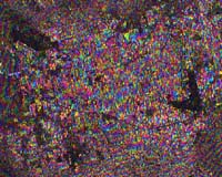
Paris (ESA) May 13, 2003 With its casinos and neon lights, Las Vegas may be the Glitter Capital of the world, but two ESA radar images of the city have come together in another kind of glitter showcase. In an ESA first, radar images from the Envisat and ERS-2 satellites were processed by researchers at the German Aerospace Centre (DLR) and combined to produce a topographic analysis of the area in and around the US city. The analysis matched data acquired in 1999 by the synthetic aperture radar (SAR) onboard ERS-2 with imagery acquired last year by Envisat's Advanced SAR to produce the accompanying interferogram. Although it might look like something hung on a university student's wall, an interferogram is actually an image generated by analysing the differences between two radar signals taken over the same area on Earth. This one shows an area of approximately 30 x 35 km around Las Vegas. The city is visible in the centre of the image as an area of bright colours, with the city's major thoroughfares appearing as straight dark lines. The image was produced by the Oberpfaffenhofen Remote Sensing Technology Institute of the German Aerospace Centre (DLR) under an ESA project to study the uses of joint ERS and Envisat data. Each colour cycle in the image, from blue to red to yellow, represents an elevation change of 8.4 metres. The effect produces bands of colours showing the topography of the city and surrounding area. Originally thought impossible Producing an interferogram with data from these two satellites was not thought initially to be feasible. Although creating interferograms from SAR images is not new, they usually are generated from images acquired by the same or compatible radars. What makes this interferogram stand out, according to Nico Adam, the DLR scientist who headed the effort, is that the SARs on ERS-2 and Envisat operate at slightly different frequencies, enough to complicate the joint processing of data from the ERS and Envisat sensors. "This is the first time that the mixing of Envisat and ERS data is performed because it requires specific geometric conditions which have been met for this demonstration," Adam said. The result highlights the ingenuity of European scientists and provides evidence that new ideas for future satellites can be found by doing with the existing ones what was thought to be impossible. "The practical demonstration of the radar cross-interferometry was of scientific and operational interest," Adam added. "It guarantees the continuity in the monitoring of the Earth's surface. Long time-span data series can be analysed; hence, very slow geophysical effects can be monitored and unnoticed effects can be explained even after years." ERS-1 was launched in 1991 and operated up to 1999. ERS-2 was orbited in 1995 and is still in operation. Envisat was launched last year carrying a suite of 10 sensors to monitor various aspects of the Earth's environment. The interferometric use of ERS and Envisat imagery will be the central topic to be discussed later this year at the Fringe 2003 Workshop, 2-5 December, at ESA's ESRIN facility outside of Rome. All scientific investigators carrying research and applications development in interferometry using ESA data are expected to be in attendance. Community Email This Article Comment On This Article Related Links Fringe workshop POLinSAR 2003 Envisat SpaceDaily Search SpaceDaily Subscribe To SpaceDaily Express Earth Observation News - Suppiliers, Technology and Application
 New York NY (SPX) Jan 11, 2006
The importance of remotely sensed data and technologies to support natural disasters has prompted attention and action in Washington. New initiatives and legislation authorizing appropriations to the remote sensing industry will be discussed at Strategic Research Institute's U.S. Commercial Remote Sensing Industry conference, scheduled for February 9-10, 2006 in Washington D.C. |
|
| The content herein, unless otherwise known to be public domain, are Copyright 1995-2006 - SpaceDaily.AFP and UPI Wire Stories are copyright Agence France-Presse and United Press International. ESA PortalReports are copyright European Space Agency. All NASA sourced material is public domain. Additionalcopyrights may apply in whole or part to other bona fide parties. Advertising does not imply endorsement,agreement or approval of any opinions, statements or information provided by SpaceDaily on any Web page published or hosted by SpaceDaily. Privacy Statement |