 |
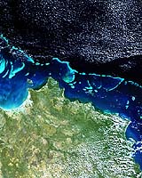
Paris (ESA) Jul 11, 2005 This Envisat image shows part of the world's largest coral reef, the 2300-kilometre-long Great Barrier Reef off Australia's Queensland coast, just beneath the sea surface. Properly speaking, the Great Barrier Reef is an interlinked system of about 3000 reefs and 900 coral islands, divided by narrow passages. An area of biodiversity equal in importance to tropical rainforests, the Reef was made a UNESCO World Heritage Site in 1981. Around a third of the Reef is protected as part of Australia's Great Barrier Reef Marine Park, the largest marine park in the world. Home to sharks, turtles, and 1500 tropical fish species, the Great Barrier Reef is a popular destination for scuba divers and many cities across the Queensland coast offer daily boat trips for tourists. The section of Reef seen here is towards its northern extremity, known as the Far Northern Management Area. The Reef was formed by colonies of coral polyps, which thrive in the warm, shallow waters of the Coral Sea. Each polyp lives inside a shell of aragonite, a type of calcium carbonate, and the polyps join together to form the distinctive, intricate patterns of coral. The colour in coral comes from associated species of algae that serve as food to the coral polyps. Only live coral has colour, with dead coral appearing white. Live coral grows on the accumulated skeletons of dead coral, so the Reef as a whole is growing between one and two centimetres annually. There have been reefs off the northeast coast of Australia for around 17 million years, ever since the drifting continent entered tropical waters. The Great Barrier Reef as we know it originated during the last Ice Age between 8000 and 10 000 years ago, when melting ice gradually inundated the edge of the continental shelf, forming an area suitable for coral to colonise. Queensland has no major rivers and few big towns, so the corals here are less stressed by environmental pollution than comparable reefs elsewhere. However around 400 reefs are in areas where the water quality is classed as having declined due to sediment and chemical runoff from farming, and the loss of coastal wetlands which in the past would have worked like a natural barrier. Coral reefs worldwide are increasingly under threat from coral bleaching, where the algae is expelled from the coral tissue, progressively losing its colour and eventually dying. The precise reason for coral bleaching is unknown but the phenomenon is associated with increased water temperatures, low salinity and high sunlight levels. The image is centred on Cape Melville National Park in Cape York Peninsula, a remote area of coastal mangroves, tropical rainforest, heathlands, woodlands and grasslands. The islands just offshore of Cape Melville are the Flinders Group National Park, rocky islands known for Aboriginal rock art. The mangrove-fringed bay to their west is Princess Charlotte Bay. Envisat's Medium Resolution Imaging Spectrometer (MERIS) acquired the image from which this crop has been taken on 19 August 2004, working in Full Resolution mode to yield a spatial resolution of 300 metres. The crop covers 326 by 326 kilometres. Community Email This Article Comment On This Article Related Links SpaceDaily Search SpaceDaily Subscribe To SpaceDaily Express Earth Observation News - Suppiliers, Technology and Application
 New York NY (SPX) Jan 11, 2006
The importance of remotely sensed data and technologies to support natural disasters has prompted attention and action in Washington. New initiatives and legislation authorizing appropriations to the remote sensing industry will be discussed at Strategic Research Institute's U.S. Commercial Remote Sensing Industry conference, scheduled for February 9-10, 2006 in Washington D.C. |
|
| The content herein, unless otherwise known to be public domain, are Copyright 1995-2006 - SpaceDaily.AFP and UPI Wire Stories are copyright Agence France-Presse and United Press International. ESA PortalReports are copyright European Space Agency. All NASA sourced material is public domain. Additionalcopyrights may apply in whole or part to other bona fide parties. Advertising does not imply endorsement,agreement or approval of any opinions, statements or information provided by SpaceDaily on any Web page published or hosted by SpaceDaily. Privacy Statement |
