|
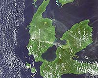
Paris, France (ESA) Jul 24, 2007 Indonesia's Mount Gamkonora volcano is spewing hot ash and smoke into the air, as seen in this image taken by the MERIS instrument aboard ESA's satellite Envisat, causing more than 8000 people to be evacuated amid fears of an imminent eruption, according to officials. Officials raised the alert to the highest level on Tuesday after the volcano, located in the eastern province of North Maluku, started spitting out flaming material, indicating magma was approaching the crater's surface making an eruption more likely, Saut Simatupang of Indonesia's Vulcanological Survey told Reuters news agency. The 1635m volcano, located about 2400 km northeast of Jakarta, began releasing smoke and ash on Saturday and spewed it as high as 4000m on Monday. Mount Gamkonora is the highest peak on Halmahera Island. Indonesia is located within the Pacific 'Ring of Fire', a continuous line (40 000 km long) of volcanoes and fault lines circling the edges of the Pacific Ocean, and has more than a hundred active volcanoes within its territory. The majority of the 1500 active volcanoes on the Earth's surface, of which around 50 erupt each year, are located along the Pacific 'Ring of Fire'. At least 500 million people live close to an active volcano. As world population increases, so does the potential threat from every eruption. Although there is no way ground-based monitoring can be carried out on all volcanoes across the globe, space-based monitoring helps identify the volcanoes presenting the greatest danger. Satellite radar, such as that aboard Envisat and ERS-2, allows scientists to track small changes in the Earth's movement that improves their ability to predict volcanic eruptions. Synthetic Aperture Radar Interferometry, InSAR for short, involves mathematically combining different radar images, acquired from as near as possible to the same point in space at different times, to create digital elevation models and reveal otherwise undetectable changes occurring between image acquisitions. Combined radar and optical data acquired from space are also very useful when an eruption begins. The synoptic view taken from optical and radar instruments aboard Envisat can simultaneously show the ash plume, the ash falling area, the lava streams and the volcanic cone shrinkage or expansion. Atmospheric sensors are used to identify the gases and aerosols released by the eruption, and quantify their wider environmental impact. Having access to these data over long periods of time is important for scientists to identify and analyse long-term trends and changes. ESA now has a 16-year archive of homogenous data thanks to the continuity of satellites ERS-1, ERS-2 and Envisat. Envisat and ERS-2, with a difference in overpass time of 30 minutes, are continually adding to the archive. Community Email This Article Comment On This Article Related Links Envisat Earth Observation News - Suppiliers, Technology and Application
 Paris, France (SPX) Jul 24, 2007
Initial results from an extensive ESA field campaign, which is being carried out in support of the development of the GMES Sentinel-2 mission and the candidate Earth Explorer FLEX mission, prove encouraging and could pave the way for future monitoring of the Earth's surface. Since one of the most important aspects of developing an Earth-observation (EO) mission is to make sure the eventual data meets the users' exacting requirements, huge efforts are put into field activities to evaluate the future performance of an instrument. |
|
| The content herein, unless otherwise known to be public domain, are Copyright 1995-2007 - SpaceDaily.AFP and UPI Wire Stories are copyright Agence France-Presse and United Press International. ESA Portal Reports are copyright European Space Agency. All NASA sourced material is public domain. Additional copyrights may apply in whole or part to other bona fide parties. Advertising does not imply endorsement,agreement or approval of any opinions, statements or information provided by SpaceDaily on any Web page published or hosted by SpaceDaily. Privacy Statement |