|
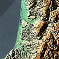
Cape Canaveral (AFP) February 13, 2000 - The shuttle Endeavour on Sunday hurtled flawlessly through space, its two antennae trained on the surface of the Earth 233 kilometers (144) miles below to gather data for the most detailed map of the planet ever made. The six astronauts aboard Endeavour, which lifted off on Friday on an 11-day mission, activated the antennae on Saturday and began creating a three-dimensional map of Earth using sophisticated radar equipment. The shuttle crew, four Americans, a German and a Japanese astronaut, are working in teams of three, changing shifts every 12 hours, to monitor equipment and replace the tape recording bands that will store billions of data units. Six hours after lift-off, commander Kevin Kregel and two mission specialists, Janet Kavandi and German colleague Gerhard Thiele, successfully deployed a mast 60 meters (200 feet) in length, at the end of which is affixed one of two antennae that are gathering radio waves reflected off the Earth. Then, co-pilot Dom Gorie and his team, specialists Mamoru Mohri of Japan and Janice Voss, activated the shuttle's own radar antenna as the craft passed over Sri Lanka, the Maldives Islands and Asia. The use of radar to bounce signals off a foreign object and analyze them upon their return is nothing new. But the Endeavour mission for the first time is using a technique called radar interferometry, which allows mapping in three dimensions through the simultaneous use of two radar receptors placed close to each other. Endeavour's main antenna, installed in its payload bay, sends very high-frequency signals toward Earth. But when they bounce back, they are received not only by the main antenna but also by the second one at the end of the mast. This second antenna, located at a distance from the first, is the principal new element of the Endeavour's Shuttle Radar Topography Mission. It allows the production of a second, separate picture of the Earth, differing just slightly from that produced by the first antenna by virtue of its slightly different viewpoint. The resulting "stereo" image is then converted by computer into three-dimensional form, much the way a person's two eyes, spaced slightly apart, allow the human brain the capacity for depth perception. Endeavour will orbit Earth 143 times, with the antennae mapping about 72 percent of the planet's above-water land and nearly 95 percent of its populated zones. At present, according to Kregel, a three-dimensional map of Earth does not exist. "We have a better three-dimensional map of Venus and Mars than of Earth," he said. With horizontal definition of 30 meters (100 feet) and vertical precision of six meters (20 feet), the map will be the most detailed picture of the planet ever made. Only the part of the map showing the United States in detail is to be published, with the remainder held by the US Defense Department and accessible to scientists under certain conditions. The mission is being undertaken for the National Imagery and Mapping Agency (NIMA), a branch of the US Defense Department, which contributed 200 million dollars to the 364 million dollar project. The shuttle will record measurements from space for nine days, collecting data between the latitudes of 60 degrees north and 56 degrees south -- stretching from Greenland to the tip of South America. The map can be used to note seismic faults, potential lava flows, landslides and floods as well as to plan for the construction of bridges, dams, pipelines and the placement of towers used in cellular communications.
Email This Article Comment On This Article Related Links Space
 Calcutta, India (SPX) Dec 28, 2005
The successful launch Thursday of India's heaviest satellite from spaceport of Kourou in French Guyana may have boosted the country's space research efforts to yet another level, but it has also lifted the spirits of at least three Direct-To-Home televisions broadcasters, one of which has been waiting for years to launch its services in India. |
|
|
|
|
|
|
|
|
|
|
|
|
|
| The content herein, unless otherwise known to be public domain, are Copyright 1995-2006 - SpaceDaily.AFP and UPI Wire Stories are copyright Agence France-Presse and United Press International. ESA PortalReports are copyright European Space Agency. All NASA sourced material is public domain. Additionalcopyrights may apply in whole or part to other bona fide parties. Advertising does not imply endorsement,agreement or approval of any opinions, statements or information provided by SpaceDaily on any Web page published or hosted by SpaceDaily. Privacy Statement |