|
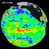
Pasadena CA (SPX) Nov 18, 2004 Recent sea-level height data from the U.S./France Jason altimetric satellite during a 10-day cycle ending November 15, 2004, show that the central equatorial Pacific continues to exhibit an area of higher-than-normal sea surface heights (indicating warmer-than-normal sea surface temperatures) between 180 degrees West and 130 degrees West. This feature, should it continue and spread eastward through November and December, could elevate the present weak El Nino episode to a moderate or stronger event. Previous warmings over the past several months, however, have dissipated. Scientists will continue to monitor the Pacific closely for further signs of El Nio intensity and development. The image shows a red area in the central equatorial Pacific that is about 10 centimeters (4 inches) above normal. These regions contrast with the Gulf of Alaska, where lower-than-normal sea levels (blue areas) continue that are between 5 and 13 centimeters (2 and 5 inches) below normal. Along the equator, the red sea surface heights equate to sea surface temperature departures greater than one degree Celsius (two degrees Fahrenheit). These images show sea surface height anomalies with the seasonal cycle (the effects of summer, fall, winter, and spring) removed. The differences between what we see and what is normal for different times and regions are called anomalies, or residuals. When oceanographers and climatologists view these "anomalies" they can identify unusual patterns and can tell us how heat is being stored in the ocean to influence future planetary climate events. Each image is a 10-day average of data, ending on the date indicated. Community Email This Article Comment On This Article Related Links Latest Jason-1 SpaceDaily Search SpaceDaily Subscribe To SpaceDaily Express Earth Observation News - Suppiliers, Technology and Application
The National Geospatial-Intelligence Agency (NGA) Friday awarded a $24-million satellite imagery contract extension to Space Imaging. This ClearView contract option enables the NGA to acquire additional commercial imagery from Space Imaging's IKONOS satellite for another year. |
|
| The content herein, unless otherwise known to be public domain, are Copyright 1995-2006 - SpaceDaily.AFP and UPI Wire Stories are copyright Agence France-Presse and United Press International. ESA PortalReports are copyright European Space Agency. All NASA sourced material is public domain. Additionalcopyrights may apply in whole or part to other bona fide parties. Advertising does not imply endorsement,agreement or approval of any opinions, statements or information provided by SpaceDaily on any Web page published or hosted by SpaceDaily. Privacy Statement |