|
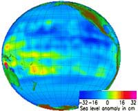
Paris (ESA) Mar 4, 2002 Four years ago, torrential rains battered the Southern US, mudslides struck in Peru -- and the inhabitants of Canada's west coast saved up to 30% on their winter heating bills. The cause? El Nino, a huge temperature shift in the Pacific Ocean which spawns climate changes globally. Today, using satellite Earth observation data, scientists are detecting the early warning signs of a new El Nino event and predicting that it will develop over the next 3 to 6 months, bringing climate changes to countries thousands of miles from the western Pacific, birthplace of the event itself. "In normal years, there's a large area of warm water in the western Pacific and colder water at the eastern side. In El Nino years, that warm water shifts eastward, which has major effects on the atmosphere above the ocean and thus the climate of the nearby countries," explains Joel Picaut, of France's Centre National d'Etudes Spatiales. Imaging from space using radar altimetry and sea surface temperature measurements reveals that the trade winds near the Equator pile up a mass of water, warmed by the sun on its journey across the Pacific, which covers an area the size of Europe. This so-called 'warm pool' off the Philippine coast is in fact a plateau in the sea some 30 cm high and with a temperature of approximately 29 C -- 5 C above average. In contrast, the water off the Galapagos Islands on the other side of the Pacific is normally a mere 20 C. When an El Nino event takes place, all this changes. "No one is yet quite sure of the mechanism that causes an El Nino," comments Picaut. "It's clear that the movement of the warm water and the change in the wind patterns are closely linked, but we do not yet know which is the cause and which the effect." The warm water in the west causes convection in the atmosphere and a relatively constant wind from east to west -- the trade winds. When the El Nino cycle begins, the trade winds reduce, no longer pushing water toward the warm pool and the mass of warm water begins to flow eastward, toward the Galapagos Islands and the Peruvian coast. "Over a period of 1-2 weeks, we see so-called 'westerly wind bursts', in which the direction of the trade winds reverses. At the equator, you see a very interesting effect, where the wind and the Earth's rotation combine to trigger 'Kelvin waves', which are like a wall of water 30 cm high moving across the pacific at about 200 km per day. You can see the Kelvin waves clearly and monitor their progress using radar altimeter and sea surface temperature data," says Picaut. These fast-moving Kelvin waves are the heralds of the more sedate progress of the main body of water, which travels at only 30 km per day. In January, scientists detected such a Kelvin wave near the International Date Line in the central Pacific.
|