|
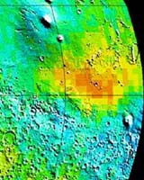
Moffett Field - Jan 09, 2004 There is one question that the Spirit rover's mission will try to answer. Which primordial elements dominated the crater formation at Gusev? Among the choices are fire (volcanism), water (ponding or glacial), impacts (dust) or wind? Mars seems to offer three elements in abundance: earth, wind and at least ancient fire. [Mars is home to the largest volcano in the solar system, appropriately named Mount Olympus]. Is Mars missing water? One hint in this search for water is an even more primordial element, the most common one in the universe, hydrogen. There is alot of hydrogen, relatively speaking, at Spirit's landing site, Gusev, and Opportunity's destination in two weeks, Terra Meridiani. Hydrogen offers a signature that points to water, H2O. Hydrogen is found mainly at the polar latitudes on Mars, that much is clear from what the orbiter, Mars Odyssey, can detect. The top banner image shows three views of Gusev--global, regional and local. The colored images show relative hydrogen abundance, with blue as the highest. The white rectangles show the familiar bowl shape at Gusev crater, with its southern delta, Ma'adim Vallis, that makes this region appear to have once witnessed erosion. The punchline in the search for water is this: of all the places to land near the equator, those in blue might have the best chance for sub-surface water, either as ice or aqueous minerals. While it might be that the darkest blue is at the poles, this rugged, frosty terrain is difficult to get to. Engineers want to land the rover near the equator, so that longer sun exposure can keep Spirit's batteries going for an extended surface mission. This tradeoff leads to favoring the equatorial blue shown in the banner image of hydrogen abundances. How can an orbiting spacecraft look for water, without actually being on the surface? The answer depends on an even more primordial element than hydrogen, which are the neutral subatomic particles called neutrons. The Mars Odyssey neutron spectrometer looks for neutrons generated when galactic cosmic rays slam into the nuclei of atoms on the planet's surface. These collisions eject neutrons skyward with enough energy to reach the orbiting spacecraft. Elements create their own unique distribution of neutron energy - called fast, thermal or epithermal - and these neutron flux signatures allow scientists to map the soil's elemental composition. During the spacecraft's 1000-day science mission, a neutron spectrometer, from its orbit 250 miles off Mars' surface, has continued to measure neutrons that leak outward from the upper meter of the Martian soil. By looking for a decrease in neutron flux the scientists can locate hydrogen. Hydrogen in the soil efficiently absorbs the energy from neutrons, reducing their flux in the surface and also the flux that escapes the surface to space where it is detected by the spectrometer. Since hydrogen is most likely in the form of water-ice, the spectrometer can measure directly, a meter deep into the Martian surface, the amount of ground ice and how it changes with the seasons. In the map of hydrogen abundance from orbit, Gusev shows a high hydrogen abundance. The hydrogen abundance at Gusev and Meridiani are similar to that closer to the poles (~50% latitude) and could represent between 20-50% of subsurface H2O within one meter of the surface. This is particularly intriguing because Gusev and Terra Meridiani (the destination for the companion Opportunity rover) are positioned as one of only several equatorial areas with high hydrogen compositions. Inspection of the map shows high hydrogen content in surface soils south of about negative 60 degree latitude and in a ring that almost surrounds the north polar cap. The maximum intensity in the northern ring coincides with a region of high surface brightness (albedo) and low thermal inertia, which are both required for near-surface water ice to be stable at latitudes equatorward of about positive/negative 60 degree latitude. Also seen are large regions near the equator that contain enhanced near-surface hydrogen, which is most likely in the form of chemically and/or physically bound water and/or hydroxyl radicals because water ice is not stable near the equator. This map has led to a number of working hypotheses about the forces at work within Gusev, some of which should be testable as 'ground truth' for orbital measurements. Suppose, for instance,
--Ice is close to the surface in Gusev and stable today
How to look for ice? The abrasion tool (RAT) may expose this icy-richness. The Mini-TES instrument can identify the chemical spectra of icy or hydrated minerals, while also looking at temperatures or water vapor. The microscopic imager can get up-close to any ice crystals. The APXS can analyze the elements in the soil. The Mossbauer spectrometer is geared to look directly for iron-bearing minerals, along with carbonates, sulfates and nitrates that are found in a ponding environment.
How to look for aqueous minerals? Rover's instrument suite, called Athena. Scientist can look for near-surface ice and aqueous minerals with their instrument suite. Credit: NASA/JPL/Cornell If Gusev never was a lake, it may still be pooling part of what are thought to be cyclic freezes that deposit ice from the atmosphere. This is called the 'White Mars' hypothesis, owing much to Nick Hoffman's research. Such airfall deposits would likely not show the same rock stratification expected in an ancient lakebed. Because grain sizes might be governed by periodic atmospheric freezes, they are likely much smaller than sediments expected from a lake bed. If water is found or not, as part of Gusev, there are still further interpretations possible for the erosion channel that runs in or out of the crater to the south. Called Ma'adim Vallis, it may have served as a sustained delta, or be part of a short-lived and catastrophic outburst. Rounded sand grains might help distinguish the lifetime of this river (fluvial) channel, as such weathering requires longer times to shape the sand or sediments. In the absence of water, flowing lava could offer the first chance to study the ancient effect of the nearby volcano, Apollinaris Patera--about 120 miles to the northwest. What sediments and smoother rocks might represent as supporting observations for the water hypothesis, then glassy shards rich in silica might point to volcanic origins. If sedimentary, water is in play; if glassy, then fire is in play. Since Gusev may be nearly 3.9 billion years old, its present location near the equator may not have always been the same. Pole shifts may suggest that Gusev deposits used to be closer to glaciers, if it had considerably colder latitudes across its large climate history. A distinguishing characteristic of such glacial lakes is layering, with a mixture of dust and volatiles that extend and retreat seasonally. Spectacular glacial layers have been imaged from orbit elsewhere on Mars, including intricate flow-like twists and turns that change with retreating frost. Most scientists see evidence for dust, wind and fire in action at Gusev. As Dr. Ray Avridson, of Washington University and deputy principal investigator for MER, put it, the outcome of water's role at Gusev may "depend on who's on top, the volcano or the lake." Article is courtesy of NASA's Astrobiology Magazine team at Ames Research Center. This article is public domain and available for reprint with appropriate credit. Community Email This Article Comment On This Article Related Links Mars at JPL MERs at Cornell SpaceDaily Search SpaceDaily Subscribe To SpaceDaily Express Mars News and Information at MarsDaily.com Lunar Dreams and more
 Pasadena CA (JPL) Jan 09, 2006
Last week Spirit completed robotic-arm work on "El Dorado." The rover used all three of its spectrometers plus the microscopic imager for readings over the New Year's weekend. |
|
| The content herein, unless otherwise known to be public domain, are Copyright 1995-2006 - SpaceDaily.AFP and UPI Wire Stories are copyright Agence France-Presse and United Press International. ESA PortalReports are copyright European Space Agency. All NASA sourced material is public domain. Additionalcopyrights may apply in whole or part to other bona fide parties. Advertising does not imply endorsement,agreement or approval of any opinions, statements or information provided by SpaceDaily on any Web page published or hosted by SpaceDaily. Privacy Statement |