|
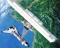
Broomfield - January 31, 2000 - Radar antennas designed and manufactured by Ball Aerospace & Technologies Corp., will rocket into orbit aboard the Space Shuttle Endeavour on Monday, Jan. 31, 2000, as part of the Shuttle Radar Topography Mission (STS-99) undertaken by NASA's Jet Propulsion Laboratory (JPL). The mission will collect data over 80 percent of the planet's landmass for the National Image and Mapping Agency (NIMA). NIMA will use the information to create the most accurate and complete topographic map of Earth ever assembled. Ball Aerospace, an industry leader in antenna technology for more than three decades, designed the original Spaceborne Imaging Radar-C (SIR-C) antennas that were used to create maps on two previous shuttle missions in 1994. To augment these original 40-foot, 23,100-pound antennas, Ball Aerospace built an additional, smaller receiving antenna that is mounted on the end of a 200-foot mast. The mast and antenna are deployed while the shuttle is in orbit 145 miles above Earth. Once in orbit, the instrument will send radar pulses to the Earth's surface, and both antennas will receive the energy reflected back from the terrain. These data will be processed using a technique called interferometry, which essentially allows scientists to create 3-D views of the Earth's surface. "It's pretty amazing what we can do in just 11 days," says Gary Salisbury, director of programs for Ball Aerospace's Advanced Antenna & Video Systems. "SRTM will be able see through thick cloud cover and dense areas like rainforests to map areas never seen before from space." The radar will image mountains and deep valleys in the Andes, Himalayas and Rocky Mountains; vast expanses of deserts and coastal plains; as well as cold regions and forests of northern latitudes. The mission will also map vestiges of ancient human settlements, such as the eighth-century Khmer civilization of Angkor, Cambodia. Data from the mission will be used by NIMA to build a digital, global elevation map with data points spaced roughly every 100 feet. The current global elevation map uses data points spaced every 330 feet and covers only 65 percent of the Earth's landmass. "The really unique thing about this mission is that we've taken a scientific instrument and adapted it to produce a data product," Salisbury says. The data will have a wide variety of applications including military and commercial uses. Salisbury says scientists will be able to use the maps for studying environment changes in areas previously unavailable. Military applications could include mission planning, modeling and simulation. A key commercial benefit, says Gary Rait, Ball Aerospace antenna system engineer for both SIR-C and SRTM, is to commercial airlines. "Because mapping quality is so poor in some areas of the world, pilots have very little accurate information about the location of mountain ranges," he says. "They can get into a lot of trouble when bad weather reduces visibility. SRTM's highly improved mapping data will help prevent planes crashing into mountainsides."
Email This Article Comment On This Article Related Links Space
 Calcutta, India (SPX) Dec 28, 2005
The successful launch Thursday of India's heaviest satellite from spaceport of Kourou in French Guyana may have boosted the country's space research efforts to yet another level, but it has also lifted the spirits of at least three Direct-To-Home televisions broadcasters, one of which has been waiting for years to launch its services in India. |
|
|
|
|
|
|
|
|
|
|
|
|
|
| The content herein, unless otherwise known to be public domain, are Copyright 1995-2006 - SpaceDaily.AFP and UPI Wire Stories are copyright Agence France-Presse and United Press International. ESA PortalReports are copyright European Space Agency. All NASA sourced material is public domain. Additionalcopyrights may apply in whole or part to other bona fide parties. Advertising does not imply endorsement,agreement or approval of any opinions, statements or information provided by SpaceDaily on any Web page published or hosted by SpaceDaily. Privacy Statement |