 |
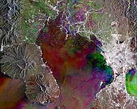
Paris (ESA) Aug 25, 2005 The capital city of the Philippines and its surrounding metropolitan area, one of the most densely populated urban areas in the world, shows up brightly in this Envisat multitemporal radar composite. 'Metro Manila' is located on the country's main island of Luzon in the South China Sea, with Manila Bay to its west and Laguna Bay to its east. Manila and its surrounding towns make up a thriving metropolitan area of more than ten million people, overseen by the Metro Manila Development Authority. The city of Manila proper lies on the west coast while the most populous single suburb of Quezon City is to its east. Home to the Philippines' major political and cultural institutions, the country's Stock Exchange and the Asian Development Bank, Manila is also the principal port of entry for imported raw materials and other goods. Its large harbour can be seen on its western side in this image, at the mouth of the Pasig River running through the city centre. Also visible to the south of the Pasig River are the runways of Ninoy Aquino International Airport. Manila originated as a small seaport on the mouth of the Pasig River in the 12th Century. Captured by Spain in 1570 it became the seat of their colony in the Philippines for more than 300 years. It became significant as a main base of the Mexico to China trading known as 'Manila Galleons'. Many Chinese traders came to Manila, making their base in Binondo, north of the river, which still remains an important business centre. Eventually agricultural exporting came to replace the galleon trade as a source of prosperity. Manila came under United States rule in 1902 and saw a fivefold increase in size during the next four decades, although underwent damage during the Japanese occupation in World War Two. Manila today remains the country's growth centre, although it suffers from chronic overcrowding, congestion, pollution and a permanent housing crisis. Only a tenth of dwellings are connected to the sanitation grid, inhabitants having to make use of the canals which run through the area � the largest of which can be seen here. Often choked by dumped refuse, these canals are prone to flooding during heavy rains, inundating roads to cause traffic jams, while the dry season can lead to water shortages. Northwest of Manila are notable fields left waterlogged all year round, probably for intensive rice production, with canals between them. On the opposite side of Manila Bay to Manila on the Bataan Peninsula is seen the peak of the Mariveles volcano (not known to have erupted in historical memory) with settlements along the coast including the town of Balanga. Because radar images represent surface backscatter rather than reflected light, there is no colour in a standard radar image. Instead the colour in this image is due to it being a multitemporal composite, made up of three Advanced Synthetic Aperture Radar (ASAR) images acquired on different dates, with separate colours assigned to each acquisition to highlight differences between them. In this composite red relates to an acquisition on 04 November 2004, green to one on 2 July 2003 and blue to one on 19 March 2003. The view was acquired in ASAR Image Mode Precision, with pixel sampling of 12.5 metres. Community Email This Article Comment On This Article Related Links SpaceDaily Search SpaceDaily Subscribe To SpaceDaily Express Earth Observation News - Suppiliers, Technology and Application
 New York NY (SPX) Jan 11, 2006
The importance of remotely sensed data and technologies to support natural disasters has prompted attention and action in Washington. New initiatives and legislation authorizing appropriations to the remote sensing industry will be discussed at Strategic Research Institute's U.S. Commercial Remote Sensing Industry conference, scheduled for February 9-10, 2006 in Washington D.C. |
|
| The content herein, unless otherwise known to be public domain, are Copyright 1995-2006 - SpaceDaily.AFP and UPI Wire Stories are copyright Agence France-Presse and United Press International. ESA PortalReports are copyright European Space Agency. All NASA sourced material is public domain. Additionalcopyrights may apply in whole or part to other bona fide parties. Advertising does not imply endorsement,agreement or approval of any opinions, statements or information provided by SpaceDaily on any Web page published or hosted by SpaceDaily. Privacy Statement |
