|
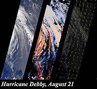
Pasadena - Oct. 25, 2000 Scientists have developed new methods of retrieving information about cloud heights, winds, airborne particles, and Earth's surface using data from the Multi-angle Imaging SpectroRadiometer (MISR) instrument orbiting on NASA's Terra satellite. MISR acquires images of the Earth at nine angles simultaneously, using nine separate cameras pointed forward, downward, and backward along its flight path. Examples of images and atmospheric information that MISR can provide are available at The first example gives three views of Hurricane Debby. One shows the storm's eastern edge as seen by the instrument's downward-looking camera. The others display cloud heights and motions generated by taking advantage of the instrument's multi- angle stereoscopic imaging capability. The second example illustrates how MISR can detect and measure the abundance of particles, including pollution, in the atmosphere. The downward-looking view of the Appalachian Mountains looks clear, while another image, from a camera viewing at a large slant angle, reveals a thin layer of haze. The third panel is a map of the amount of airborne particulates derived from the images. These demonstrations are based upon samples of MISR's advanced data products. MISR, built and managed by the Jet Propulsion Laboratory, is one of several Earth-observing experiments aboard Terra, which was launched in December 1999. The MISR science team includes members in the United States, England, and Italy. Community Email This Article Comment On This Article Related Links MISR Atmospheric Sciences Data Center SpaceDaily Search SpaceDaily Subscribe To SpaceDaily Express Dirt, rocks and all the stuff we stand on firmly
 Moscow (XNA) Jul 03, 2005
China and Russia issued a joint statement here, last Friday, on a new 21st century world order, setting forth their common stand on major international issues, such as UN reforms, globalization, Korean North-South cooperation, and world economy and trade. |
|
|
|
|
|
|
|
|
|
|
|
|
|
| The content herein, unless otherwise known to be public domain, are Copyright 1995-2006 - SpaceDaily.AFP and UPI Wire Stories are copyright Agence France-Presse and United Press International. ESA PortalReports are copyright European Space Agency. All NASA sourced material is public domain. Additionalcopyrights may apply in whole or part to other bona fide parties. Advertising does not imply endorsement,agreement or approval of any opinions, statements or information provided by SpaceDaily on any Web page published or hosted by SpaceDaily. Privacy Statement |