|
Greenbelt (SPX) May 12, 2004 Wildfire management teams across the West gear up for one of the worst fire seasons to hit the Rockies and Southwestern United States. The National Interagency Fire Center (NIFC), nation's support center for wildlandfirefighting, predicts another above average fire season for most of the interior West in 2004. But, "we should be prepared for another severe fire season in the West." Says Rick Ochoa, National Fire Weather Program Manager from the National Interagency Fire Center. The 2002 United States wildfire season began early and grew to be the second largest in the past 50 years. Roughly 74,000 fires burned more than 7 million acres nationwide. Twenty-one firefighters lost their lives while battling U.S. fires. Arizona, Colorado and Oregon recorded their largest wildfires this century. Two particularly severe wildfires, the Rodeo-Chediski Fire in Arizona and the Hayman Fires of Colorado are examples of how drought can be used to predict fire danger. In an effort to help fire specialists better prepare for an impending wildfire season, a fleet of satellites delivers snow pack, water level and vegetative cover data that help determine the fire potential across the country.
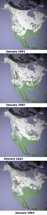
Less Snow Suggests Drier than Normal Rockies Comparing results during the same 8-day period in January for the last four consecutive years, reveals that there can be large year-to-year changes in snow cover; these changes in turn can affect the following summer?s fire season. In March of 2003, a record-breaking blizzard hit Denver, temporarily alleviating Colorado's drought and resulting fire season. The storm dropped 30 inches of snow in the valley, and as much as 87 inches in the mountains. MODIS captured images of the snow-besieged region. Although this record-setting snow alleviated the problem, it was not enough to defeat the ongoing drought. In contrast, March of this year was one of the warmest and driest on record. "Early snow melt means the fire season can start earlier and last longer, says Rob Solhberg, NASA and University of Maryland, College Park researcher." Like most western states, Colorado gets most of its liquid assets from snow. The lack of snow reserves this year pushes that state, and likely others, toward a harrowing fire season.
Satellites Show Decreasing Water Levels As the Colorado Basin enters its sixth year of drought, computer models suggest water levels will go down another 15 to 20 feet this year, according to the Bureau of Reclamation. These below average water levels are indicative of the dryness out west.
Vegetative Cover Shows Dry Rockies of 2002 The NDVI images are also useful as a measure of drought when compared to "normal" plant health. NASA scientists calculate average NDVI values for an area to find out what is normal at a particular time of year. Newly processed images show NDVI variations from what is normal in the western U.S., as measured by the vegetation instrument on Europe's SPOT satellite provided by DigitalGlobe/SPOT, under agreement with the U.S. Department of Agriculture Foreign Agricultural Service (USDA/FAS). In 2002, drought had settled across the Midwest. Large dark brown sections of eastern Colorado show where vegetation was less lush and healthy than normal.
Satellites Work Hard on Wildfires Year Round NASA partners include Forest Service Remote Sensing Applications Center (RSAC) and the USGS EROS Data Center (EDC). Spot, Landsat and MODIS imagery were key tools in planning restoration of the Hayman and Rodeo-Chedeski. In the last three fire seasons, RSAC and EDC have mapped the post-fire conditions on 163 fires covering more than 5.4 million acres. Community Email This Article Comment On This Article Related Links SpaceDaily Search SpaceDaily Subscribe To SpaceDaily Express Earth Observation News - Suppiliers, Technology and Application
 New York NY (SPX) Jan 11, 2006
The importance of remotely sensed data and technologies to support natural disasters has prompted attention and action in Washington. New initiatives and legislation authorizing appropriations to the remote sensing industry will be discussed at Strategic Research Institute's U.S. Commercial Remote Sensing Industry conference, scheduled for February 9-10, 2006 in Washington D.C. |
|
| The content herein, unless otherwise known to be public domain, are Copyright 1995-2006 - SpaceDaily.AFP and UPI Wire Stories are copyright Agence France-Presse and United Press International. ESA PortalReports are copyright European Space Agency. All NASA sourced material is public domain. Additionalcopyrights may apply in whole or part to other bona fide parties. Advertising does not imply endorsement,agreement or approval of any opinions, statements or information provided by SpaceDaily on any Web page published or hosted by SpaceDaily. Privacy Statement |