|
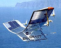
Moffett Field - Mar 14, 2002 Thanks to recent NASA research, digital pictures taken from a remotely piloted, solar-powered airplane will help growers harvest better coffee and provide support during future natural disasters. To test their aerial imaging system, researchers used remote control to take digital images of coffee fields on the Island of Kauai from a piloted, light plane. They provided these images to the harvest manager on the ground. By viewing the color patterns in the images, the manager could tell which fields were ripest, and where to send harvest machines. Choosing the fields with the highest percentage of ripe coffee cherries is crucial because harvest machines shake off all the coffee cherries in each field, whether they are ripe or not. "There is a significant difference in the value of ripe coffee cherries compared to unripe and overripe cherries," said Stanley Herwitz, professor of Earth sciences at Clark University, Worcester, Mass, who now is based at NASA's Ames Research Center in California's Silicon Valley. Herwitz also is the principal investigator for the Uninhabited Aerial Vehicle (UAV) coffee project. "The main variety of coffee grown on this particular plantation, the largest in the U.S.A., ripens to a yellow color," he said. The color of coffee cherries, which contain coffee beans, indicates the degree of ripeness. "Fields ripen very unpredictably, and independently of each other," Herwitz said. "We can take very high-resolution pictures flying over the fields, locate the ripest fields and help the harvest manager decide where to send his harvest machines to obtain the most profitable harvest." "The current method of determining field ripeness involves limited sampling of branches and counting ripe cherries versus unripe and overripe cherries," Herwitz said. "Our method provides a view of the entire plantation. For some pictures, we use filters to image only the wavelengths of interest. In that way, we can obtain imagery that emphasizes the yellow color of the ripest coffee fields," Herwitz said. "The imagery provided us with a new perspective in our effort to detect ripe coffee fields," the harvest manager at the Kauai Coffee Company, a research partner said. "We plan to continue to refer to this readily accessible imagery over the next several months as we conclude our harvest operation and focus our efforts on irrigation and weed control," he added during last year's post-harvest season. Digital aerial images also can aid growers by showing the location of vines that can jam coffee-harvesting machines. In addition, one of the cameras takes digital pictures of infrared light, which is invisible to human beings. Scientists represent infrared light with visible, bright colors in pictures. This aerial infrared imagery helps researchers detect fungal disease, water stress and insect infestation in many types of plants. In the tropics, clouds and their shadows often pass over the fields, even on typically sunny days, preventing completely clear views in single aerial pictures. To overcome this problem during the 2002 Hawaiian coffee harvest, the research team will fly the Pathfinder Plus, a remote-controlled, solar-powered airplane, which can circle as long as 16 hours. The unique loitering ability of the airplane will enable it to acquire enough images so they can be assembled into a mosaic of cloudless imagery of the entire plantation. Eventually, designers hope to fly solar-powered UAV aircraft for weeks to months at a time without landing. "Our immediate objective is to demonstrate the commercial potential of a solar UAV airplane to linger over fields for as long as it takes to acquire cloudless imagery, as well as watch the fields ripen during the 2002 Kauai harvest season," said Herwitz. Field ripeness can change dramatically in a few days, he said. During the 2001 Hawaiian coffee harvest season, the research team tested the imaging systems they will use on the solar airplane for the 2002 harvest. Scientists on the ground used wireless technology to control their digital cameras on a piloted light aircraft and transmitted large, 20-megabyte images to their ground station in as little as 35 seconds. "We were in Kauai for three weeks, and we acquired more than 2,000 images," Herwitz said. "Our long-term goal is to develop the imaging technology aboard solar-powered UAV airplanes to help people to cope with natural and other disasters, as well as to assist farmers who grow a wide variety of crops," said Herwitz. "Corn and wheat are candidates for this kind of precision agriculture research because the scale of production is so huge," Herwitz said. "The goal is to help growers manage their fields at a high level of efficiency. Real-time imaging can help those farmers who may need quick updates of ripeness conditions of crops or any other treatments such as fertilizers, irrigation and pest control." Using their imaging system aboard the solar-powered airplane, the research team will obtain much higher resolution images than are available from satellites. "The solar-powered UAV will fly much closer to the Earth than orbiting satellites, and the result will be much sharper imagery. In the near future, the solar-powered UAV will be used for multitasking jobs such as precision agriculture, communications, weather observation, disaster monitoring and emergency response," Herwitz said. Another advantage of the solar airplane is that it can land, and scientists can easily upgrade the plane's sensors, unlike a satellite that stays in orbit. The NASA UAV Science Demonstration Program is funding the $3.76 million UAV Coffee Project, which includes a team of about 15 researchers. Scientists selected the project after reviewing more than 40 UAV science proposals. Community Email This Article Comment On This Article Related Links Pathfinder UAV Project Ripe for the picking SpaceDaily Search SpaceDaily Subscribe To SpaceDaily Express Earth Observation News - Suppiliers, Technology and Application
 New York NY (SPX) Jan 11, 2006
The importance of remotely sensed data and technologies to support natural disasters has prompted attention and action in Washington. New initiatives and legislation authorizing appropriations to the remote sensing industry will be discussed at Strategic Research Institute's U.S. Commercial Remote Sensing Industry conference, scheduled for February 9-10, 2006 in Washington D.C. |
|
| The content herein, unless otherwise known to be public domain, are Copyright 1995-2006 - SpaceDaily.AFP and UPI Wire Stories are copyright Agence France-Presse and United Press International. ESA PortalReports are copyright European Space Agency. All NASA sourced material is public domain. Additionalcopyrights may apply in whole or part to other bona fide parties. Advertising does not imply endorsement,agreement or approval of any opinions, statements or information provided by SpaceDaily on any Web page published or hosted by SpaceDaily. Privacy Statement |