|
Longmont CO (SPX) May 26, 2006 DigitalGlobe's European business partner, Eurimage in Rome, Italy, has contracted with the European Commission's Joint Research Center to supply worldwide satellite imagery over a four-year period. The DigitalGlobe portion of the contract is valued at $7.7 million (6 million Euros) and will support all EC institutions, services and agencies, the company said in a statement. The JRC will use DigitalGlobe's 60-centimeter resolution QuickBird data primarily to support its Control with Remote Sensing campaign, focused on supporting the EC's Common Agricultural Policy for all 25 member countries. The reform is intended to improve agriculture management and control systems, and to prevent agricultural subsidy irregularities with the help of remote sensing, geographic information systems and other technologies. The center will use high-resolution remote sensing imagery in risk analysis and fraud detection. It will allow officers from the member states and the EC to control farmers' subsidy requests by determining crop parcels. Through better monitoring of agricultural assets, the EC can ensure its subsidies are distributed more quickly, efficiently, fairly and reliably. In addition to supporting the CwRS campaign, DigitalGlobe's QuickBird imagery will meet the EC's increasing requirements in support of security and humanitarian aid programs. Imagery from DigitalGlobe's WorldView system, scheduled to launch in mid-2007, also will be used to support the contract, the company's statement said. Eurimage also has been contracted to supply Landsat data. "This contract represents Eurimage's ongoing commitment to the EC for a variety of programs and needs, which we have supported since 1990," said Marcello Maranesi, Eurimage's managing director. "We are proud to have played an instrumental role in providing imagery to the EC during such emergencies as the Southeast Asian tsunami and the Pakistan earthquake. These experiences, combined with our involvement in the 2004 and 2005 CwRS campaigns, have been valuable in improving our products and services to meet the Earth-observation market's expectations and our clients' needs." Community Email This Article Comment On This Article Related Links QuickBird DigitalGlobe Earth Observation News - Suppiliers, Technology and Application
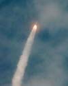 Cape Canaveral Air Force Station FL (SPX) May 26, 2006
The N version of NASA's Geostationary Operational Environmental Satellite series launched on schedule Thursday evening from Space Launch Complex 37 at Cape Canaveral Air Force Station. The Boeing Delta IV rocket carrying the satellite lifted off at the beginning of its launch window, at 6:11 p.m. Eastern Time. |
|
| The content herein, unless otherwise known to be public domain, are Copyright 1995-2006 - SpaceDaily.AFP and UPI Wire Stories are copyright Agence France-Presse and United Press International. ESA PortalReports are copyright European Space Agency. All NASA sourced material is public domain. Additionalcopyrights may apply in whole or part to other bona fide parties. Advertising does not imply endorsement,agreement or approval of any opinions, statements or information provided by SpaceDaily on any Web page published or hosted by SpaceDaily. Privacy Statement |