|
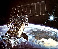
Los Angeles CA (SPX) Jul 20, 2006 "Weather" it's a hurricane, typhoon or thunderstorm in the constantly changing environment of global weather conditions, agencies behind the scenes continually provide data for distribution to Department of Defense and civilian government agencies. The Defense Meteorological Satellite Program has been providing outstanding environmental support to the nation for five decades. A DoD program run by the Air Force Space and Missile Systems Center, DMSP designs, builds, launches and maintains satellites, which monitor the meteorological, oceanographic and solar-terrestrial physics environments. "DMSP satellites are designed to meet unique military requirements for worldwide space and terrestrial weather information; however, this data is fully shared with civilian agencies," said Col. John Wagner III, DMSP director. "Through these satellites and accompanying data, military and civilian weather forecasters can detect developing weather patterns, track existing weather systems over remote areas and alert the civil and military communities of anticipated hazards to people and resources," Wagner added. DMSP satellites provide meteorological data in real time to Air Force, Army, Navy and Marine Corps tactical ground stations and Navy ships worldwide. This data is also stored in recorders on the satellites for later transmission to ground stations. From these ground stations, information is relayed to the Air Force Weather Agency at Offutt Air Force Base, Neb., and to the U.S. Navy's Fleet Numerical Meteorological and Oceanographic Center in Monterey, Calif., where it is then compiled into numerous worldwide weather and space environmental products. AFWA and FNMOC distribute these products to DoD and civilian government agencies. At the heart of DMSP's sensing capability is the Operational Linescan System. The OLS sensor employs a moving telescope technique to scan the earth in the cross track direction, while forward motion of the satellite provides the along track incremental motion. It is designed to provide pictorial meteorological cloud imagery for continuous global coverage. OLS imagery is used by severe storm forecasters to locate storms and estimate their strength. The Special Sensor Microwave Imager Sounder is another important mission sensor. The SSMIS utilizes microwave data. This information is considered essential to accurate positioning of storm centers and forecasting storm development and motion because SSMIS wind speed and rainfall rate data are not obscured by cloud cover. Hurricane and typhoon forecasting have improved significantly with the utilization of DMSP microwave imagery. The DMSP constellation is made up of two primary polar orbiting satellites. The next satellite is expected to be launched from Vandenberg AFB, Calif., in early November 2006. The last three satellites are scheduled to follow in two-year intervals beginning in April 2008 and ending in April 2012. The lifetime for DMSP satellites is four years, so coverage is expected until 2014 to 2016. DMSP will be replaced by a combination of the National Polar-Orbiting Operational Environmental Satellite System and the European MetOP satellites. (John Bohlson is with The Aerospace Corp., Capt. William Bones is with the Space and Missile Systems Center DMSP Program Office, and Jo Adail Stephenson is with SMSC Public Affairs) Community Email This Article Comment On This Article Related Links DMSP Weather News at TerraDaily.com
 Palo Alto CA (SPX) Jul 20, 2006
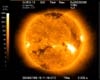
The Solar X-ray Imager on the National Oceanic and Atmospheric Administration's GOES-13 spacecraft has produced its first image: a remarkable view of the Sun in soft X-rays. |
|
| The content herein, unless otherwise known to be public domain, are Copyright 1995-2006 - SpaceDaily.AFP and UPI Wire Stories are copyright Agence France-Presse and United Press International. ESA PortalReports are copyright European Space Agency. All NASA sourced material is public domain. Additionalcopyrights may apply in whole or part to other bona fide parties. Advertising does not imply endorsement,agreement or approval of any opinions, statements or information provided by SpaceDaily on any Web page published or hosted by SpaceDaily. Privacy Statement |