|
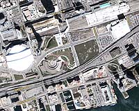
Longmont CO (SPX) Jun 08, 2005 DigitalGlobe and DMTI Spatial, a Canadian provider of geospatial products and services, have announced the immediate availability of Satellite StreetView. Satellite StreetView is an imagery-mapping solution combining high-quality digital mapping data with the highest resolution satellite imagery commercially available on the market. This groundbreaking new product combines 60-centimeter resolution QuickBird orthoimagery of entire urban areas with precisely-aligned vector map layers resulting in a real-world depiction of Canadian ground features. The integration of CanMap Streetfiles provides users with street centerline data and address lookup functionality, fully integrated with the imagery. Satellite StreetView is currently available for Toronto, Ottawa, Quebec City and Calgary. Montreal, Vancouver, Hamilton-Niagara, Halifax, Regina, Saskatoon, Windsor, Fredericton, and Saint John will be released over the next few months, with many more cities to follow. The imagery is updated annually and the mapping data is updated quarterly. Satellite StreetView serves many markets - from retailers targeting potential business opportunities by visualizing future markets of growth, to real estate developers seeking potential development areas, or government agencies implementing planning and assessment measures for security, defense and emergency preparedness strategies. "Satellite StreetView represents a whole new level in geospatial data. Satellite imagery has always been great at showing what is on the ground, but until now it has been difficult to reliably relate the features to other data. Satellite StreetView's combination of orthoimagery integrated with vector mapping provides users with a practical solution that has real-world ground truth, clean data linkages, and a wealth of detail not possible with vector data alone," said Misha Byalik, director, Product Development and Client Services at DMTI Spatial. Community Email This Article Comment On This Article Related Links DMTI Spatial DigitalGlobe SpaceDaily Search SpaceDaily Subscribe To SpaceDaily Express Earth Observation News - Suppiliers, Technology and Application
 New York NY (SPX) Jan 11, 2006
The importance of remotely sensed data and technologies to support natural disasters has prompted attention and action in Washington. New initiatives and legislation authorizing appropriations to the remote sensing industry will be discussed at Strategic Research Institute's U.S. Commercial Remote Sensing Industry conference, scheduled for February 9-10, 2006 in Washington D.C. |
|
| The content herein, unless otherwise known to be public domain, are Copyright 1995-2006 - SpaceDaily.AFP and UPI Wire Stories are copyright Agence France-Presse and United Press International. ESA PortalReports are copyright European Space Agency. All NASA sourced material is public domain. Additionalcopyrights may apply in whole or part to other bona fide parties. Advertising does not imply endorsement,agreement or approval of any opinions, statements or information provided by SpaceDaily on any Web page published or hosted by SpaceDaily. Privacy Statement |