|
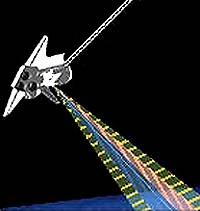
Munich - January 31, 2000 - With the help of the German radar instrument /SRTM, a three-dimensional map of the Earth will be drawn up from space. Dornier Satellitensysteme GmbH (DSS/Friedrichshafen), a company of DaimlerChrysler Aerospace AG (Dasa/Munich), developed and built this instrument which is to be used in the "Shuttle Radar Topography Mission" (SRTM). The eleven-day flight with the Space Shuttle Endeavour is expected to start from Cape Canaveral. Earth observation from the orbit is possible with various instruments. The radar sensors have many advantages: they work at day and at night, they penetrate also clouds and, in the planned configuration, they permit the generation of 3D images of the Earth's surface. The method planned for SRTM, the so-called radar interferometry, is the technologically most advanced and effective method for the acquisition of topographic information. The idea of the SRTM mission goes back to two successful space shuttle flights in spring and fall 1994 with the German/Italian X-SAR mapping radar instrument on board. Combined with the NASA-developed SIR-C instrument, multi-frequency radar data from space were recorded for the first time for geoscience and application-oriented earth observation tasks. Both missions demonstrated that these data could also be used for exact land use classification, determination of the biomass of forests, acquisition of the extent of floods, oil spills and ice on the Earth's oceans. It could also be shown that it was possible to obtain topographic data on the Earth's surface with the help of SAR interferometry. The operation during the flights of 1994 was in the so-called "multi-pass" mode, i.e. the interferometry data were acquired during different Earth orbits. In the next and also the third flight of SIR-C/SAR. data acquisition will be performed simultaneously in the so-called "single pass" mode. During the eleven-day SRTM mission, it is planned to collect data for a digital elevation model of landmasses within a range between +60 and -56 degree geographical latitude. Thus, about 80 per cent of the Earth's complete landmass will be acquired. For this purpose, it would be necessary to expand the existing X-SAR instrument by an additional receive channel and a second antenna mounted on the end of the 60 m boom. Up to now, the best global database has provided only every 1,000 meters a point with an accuracy of 100 meters in height. The SRTM sensors will provide every 30 meters a point with an accuracy of 6 meters in height. This worldwide unique database will offer manifold utilization possibilities, for instance, in the fields of mobile radio communication (radio-wave propagation), navigation, water resources, disaster management (prevention, operation, evaluation) traffic infrastructure planning and weather forecasting/climate modeling. Organizations from 25 states have already ordered these data. Currently, the C-band and X-band interferometer are being tested with the shuttle interface and instrument operation is also being simulated via the ground station in Houston, Texas. The STRM instrument pack is to be installed into the cargo bay of Endeavour in July. The SRTM mission is also unique regarding the cost aspects. The cooperation with NASA allows flight opportunity at no charge as well as the wide use of existing hardware. In addition to four U.S. astronauts and the Japanese Marnoru Mohri, the German mission specialist Dr. Gerhard Thiele of the ESA astronaut team also belongs to the Endeavour crew. SRTM is a joint project of NASA, NIMA (National Image and Mapping Agency), DLR and ASI (Italian space agency). JPL is responsible for the development of the C-band radar interferometer and Dornier Satellitensysteme GmbH is the industrial prime contractor for the development of the X-SAR radar system.
Email This Article Comment On This Article Related Links Space
 Calcutta, India (SPX) Dec 28, 2005
The successful launch Thursday of India's heaviest satellite from spaceport of Kourou in French Guyana may have boosted the country's space research efforts to yet another level, but it has also lifted the spirits of at least three Direct-To-Home televisions broadcasters, one of which has been waiting for years to launch its services in India. |
|
|
|
|
|
|
|
|
|
|
|
|
|
| The content herein, unless otherwise known to be public domain, are Copyright 1995-2006 - SpaceDaily.AFP and UPI Wire Stories are copyright Agence France-Presse and United Press International. ESA PortalReports are copyright European Space Agency. All NASA sourced material is public domain. Additionalcopyrights may apply in whole or part to other bona fide parties. Advertising does not imply endorsement,agreement or approval of any opinions, statements or information provided by SpaceDaily on any Web page published or hosted by SpaceDaily. Privacy Statement |