|
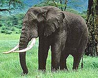
New York NY (SPX) Nov 18, 2004 Scientists with the Bronx Zoo-based Wildlife Conservation Society (WCS) have recently been counting their zoo animals from a lofty perch: namely, outer space. Using high-tech cameras fixed to an orbiting satellite 280 miles overhead, a WCS scientific team tallied some of the zoo's own animal collection to see if satellites can help count wildlife populations in remote locations throughout the world. The WCS team is currently analyzing high-tech maps produced by the satellite, which orbited the zoo last Wednesday, Nov. 10th. So far, everything from giraffes to Thomson's gazelles have been spotted with startling clarity. If the technology proves accurate, WCS is hopeful that it can be used to monitor endangered wildlife populations that live in hard-to-reach locations. Dr. Eric Sanderson, a WCS landscape ecologist who is managing the study said, "Imagine being able to monitor a herd of elephants in the Serengeti, or a flock of endangered flamingos in Bolivia, from a lab in New York." "This technology may allow us to do just that. This experiment is another powerful example of how WCS can use its world-class zoos in New York City to help save wildlife living half a world away," said Richard L. Lattis, General Director of WCS's zoos and aquarium. The satellite, called Quickbird, is owned by DigitalGlobe, a private company. WCS plans to use similar imagery to count wildlife in exotic locations, including elephants and giraffes in Tanzania, flamingos in South America, and elk, bison and antelope in Wyoming. WCS scientists will analyze those images as well to compare counts of wildlife living in other wild places. The project was funded in part by a grant from NASA. According to members of Dr. Sanderson's team, the detail of the images taken from so far away has been particularly impressive. "We're counting individual gazelles in the zoo's African Plains exhibit from a satellite 280 miles up," said Dr. Scott Bergen. "That's like standing on top of the Empire State Building and spotting a deer in Maine." Community Email This Article Comment On This Article Related Links Wildlife Conservation Society SpaceDaily Search SpaceDaily Subscribe To SpaceDaily Express Earth Observation News - Suppiliers, Technology and Application
 New York NY (SPX) Jan 11, 2006
The importance of remotely sensed data and technologies to support natural disasters has prompted attention and action in Washington. New initiatives and legislation authorizing appropriations to the remote sensing industry will be discussed at Strategic Research Institute's U.S. Commercial Remote Sensing Industry conference, scheduled for February 9-10, 2006 in Washington D.C. |
|
| The content herein, unless otherwise known to be public domain, are Copyright 1995-2006 - SpaceDaily.AFP and UPI Wire Stories are copyright Agence France-Presse and United Press International. ESA PortalReports are copyright European Space Agency. All NASA sourced material is public domain. Additionalcopyrights may apply in whole or part to other bona fide parties. Advertising does not imply endorsement,agreement or approval of any opinions, statements or information provided by SpaceDaily on any Web page published or hosted by SpaceDaily. Privacy Statement |