 |
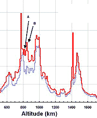
Houston - October, 2000 This article will examine changes in the low-Earth orbit (LEO) environment over the period 1990-2000. Two US Space Surveillance Network (SSN) catalogs form the basis of our comparison. Included are all unclassified cataloged and uncataloged objects in both data sets, but objects whose epoch times are "older" than 30 days were excluded from further consideration. Moreover, the components of the Mir orbital station are "collectivized" into one object so as not to depict a plethora of independently-orbiting objects at Mir's altitude; the International Space Station (ISS) is afforded the same treatment in the year 2000 data set. Figure 1 depicts the spatial density [1/km**3] over the altitude range 100-2000 km and in 10 km altitude bands. Figure 1 possesses several salient features. Perhaps the most prominent are the "spikes" located between 770-780 and 1410-1420 km altitude. These correspond to the Iridium and Globalstar commercial communication spacecraft constellations, respectively. Given the uncertain future of the Iridium constellation, the spike between 770 and 780 km may change drastically or even disappear over the next several years. Less prominent is the Orbcomm commercial constellation, with a primary concentration between 810 and 820 km altitude (peak "A" in Figure 1). Smaller series of satellites may also result in local enhancements of the population. For example, consider the peak between 840-850 km (Figure 1's peak "B"). This volume is populated by the Commonwealth of Independent State's Tselina-2 spacecraft constellation, several US Defense Meteorologica Support Program (DMSP) spacecraft, and their associated rocket bodies and debris. While the region is traversed by many other space objects, including debris, these satellites and rocket boosters are in near circular orbits. Thus, any group of spacecraft whose orbits are tightly maintained are capable of producing a spike similar to that observed with the commercial constellations. Not coincidentally, the NASA EVOLVE 4.0 long-term debris evolution computer model predicts that this region is sensitive to the collision hazard. This result appears driven by the large size and mass of the spacecraft resident there, particularly the Tselina-2 constellation. Note that both data sets presented are at or near Solar maximum. One may expect the low altitudes (<600) to increase by up to a factor of two over the next five years, given decreasing Solar activity and assuming the historical fragmentation rate. Such behavior is historically evident when comparing a 1987 SSN catalog with the 1990 data set. The spatial density chart averages over inclination; hence, collision rates won't be linearly related to the spatial density at any given altitude. Indeed, collision rates will vary not only with the spatial density but also with the inclination-dependent relative velocity. Altitudes dominated by high inclination (70-110 deg) orbits are expected to yield a significantly higher collision rate as compared to those populated by lower inclination orbits. The exception to this general rule returns us to our starting point: the commercial constellations. Because these constellations are maintained in precise orbital planes, their expected collision rate would be versus the "background" population only. Hence, the spikes representing the Iridium and Globalstar constellations do not present the inordinate collision risk implied by a casual examination.
Community Email This Article Comment On This Article Related Links SpaceDaily Search SpaceDaily Subscribe To SpaceDaily Express Space Technology News - Applications and Research
 Baltimore MD (SPX) Jan 12, 2006
A team comprised of three leading US aerospace and defense contractors has demonstrated an innovative technological use of active electronically scanned array (AESA) radars for high-bandwidth communications. |
|
|
|
|
|
|
|
|
|
|
|
|
|
| The content herein, unless otherwise known to be public domain, are Copyright 1995-2006 - SpaceDaily.AFP and UPI Wire Stories are copyright Agence France-Presse and United Press International. ESA PortalReports are copyright European Space Agency. All NASA sourced material is public domain. Additionalcopyrights may apply in whole or part to other bona fide parties. Advertising does not imply endorsement,agreement or approval of any opinions, statements or information provided by SpaceDaily on any Web page published or hosted by SpaceDaily. Privacy Statement |
