|
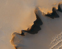
Pasadena CA (SPX) Dec 21, 2006 NASA is providing a unique opportunity to the public to suggest photo targets for the Mars Reconnaissance Orbiter (MRO), the spacecraft that recently took a history-making image of the Mars Exploration Rover Opportunity on the rim of Victoria Crater. MRO, which began orbiting Mars on March 10, 2006, carries a sharp-eyed camera called the High Resolution Imaging Science Experiment (HiRISE), that can image objects as small as an easy chair on the martian surface while the spacecraft orbits 186 miles (300 kilometers) overhead. HiRISE, with 14 charge-coupled device (CCD) detectors, takes pictures having more than 300 times more pixels than found in a typical consumer 8-megapixel camera image. As MRO continues its mission to survey our neighboring planet, NASA's Mars science team will review suggestions from the public for photo targets and task the spacecraft to take pictures of those proposed targets having the greatest scientific merit. Here are URLs to visit to make suggestions for Mars picture-taking and for viewing images: This Web site contains many images of Mars taken during previous missions and by other satellites still orbiting the planet. These wider views give Internet users a way to survey the red planet from a distance, and then zoom into closer views to pinpoint where new, even more-detailed pictures could be taken by HiRISE. "We are creating a Web site where one can virtually explore Mars using a variety of high-resolution images," said Glenn Deardorff, the HiRISE Web developer at NASA Ames Research Center, located in California's Silicon Valley. Deardorff has built the preliminary Web site with images available from Mars missions as old as the two Viking orbiters of the 1970s. The Web site includes complete directions explaining how to locate areas on Mars and make suggestions for picture taking. Generally, here's how you can make a suggestion: First, before making a proposal, the user must locate where a super-high-resolution picture is to be taken. This is done by looking at wider views of the planet, and gradually zooming in to locate interesting features. The user can select the area of interest on the Mars pictures by clicking and dragging a mouse or selecting area outlines of a HiRISE image 'footprint.' When the user does this, the Web site's HiRISE 'tool' automatically displays latitude and longitude numbers. Second, the user needs to fill in a form on-line. The selected latitude and longitude figures automatically appear in the form after the user has zeroed in on a Mars location. Then the requestor needs to choose a 'science theme' that best fits his/her suggestion. Some examples of science themes are 'volcanic,' 'glacial processes' and 'future landing sites.' There is a block where the requester must write a short justification for the suggestion. In order to submit a suggestion, one has to first register, according to Dr. Virginia Gulick, who holds a doctorate in geosciences. She also is a HiRISE science team member and education and public outreach lead from the SETI Institute, Mountain View, Calif., who works at NASA Ames. The requester will create a user name and password. These will allow the user to go back to the Web site to view his/her suggestions and to permit the HiRISE team to send return e-mail to alert suggesters when an image or images within their region/s of interest were acquired. "We are doing this because HiRISE is only going to image about 1 percent of the planet's surface, and we want to image the best - or the most interesting areas," she said. Mars' surface is about the same area as Earth's continental areas. The team also will invite Internet users to volunteer to be 'click workers.' "We will ask volunteers to help us initially locate and eventually create databases of boulders, gullies, craters - any kind of geologic feature on the surface that may be of interest in the images," Gulick explained. "The resulting databases can provide a better understanding of how these surface features formed, as well as provide better insight into the planet's geologic and climatic history," Gulick said. "Scientists or students can use these data bases to propose theories about Mars that could be proven by future exploration," she added. According to Gulick, scientists expect the mission to last at least two years. "But it may last another decade, if we're lucky, partly because we didn't have to use as much fuel as originally planned to make flight corrections on the way to Mars," she explained. The primary HiRISE science phase starts in November 2006. "That's when we begin taking pictures officially for science after the orbit circularizes," said Gulick. In addition to pictures and image submission forms, the site contains information about each HiRISE science theme. "So, if you don't know what 'aeolian processes' are, you will learn that they are wind-related. If you want to take pictures of dunes or dust tracks, then you should suggest aeolian processes as a science theme. The suggestion will then be ranked by priority by the HiRISE team members responsible for that science theme," she said. The site also will provide a way for users to browse, zoom and view extremely large HiRISE images overlaid with other Mars data such as elevation, latitude and longitude and mineral and infrared data. "For students and educators, we currently have coloring books for younger children, comic books geared for middle and high school students and activity books for kindergarten through sophomore college level," Gulick related. "These books will teach students more about Mars, and also help them learn how to make a good image suggestion," she continued. HiRISE educational materials comply with National Science Standards, and there are teacher guides for each activity book. The guides contain answers and solutions for each activity and background material. "We want to share this excellent resource with everybody," Deardorff added. "It is called the 'people's camera' by the team," he explained. Community Email This Article Comment On This Article Related Links NASA Mars Reconnaissance Orbiter All about the technology of space and more Mars News and Information at MarsDaily.com Space Technology News - Applications and Research
 Beltsville MD (SPX) Dec 21, 2006
Swales Aerospace announced today that it has completed the Critical Design Review (CDR), for the TacSat-3 Modular Bus program, which is sponsored by the Air Force Research Laboratory's Space Vehicle Directorate (AFRL/VS), as part of the Department of Defense Operationally Responsive Space initiative. |
|
| The content herein, unless otherwise known to be public domain, are Copyright 1995-2006 - SpaceDaily.AFP and UPI Wire Stories are copyright Agence France-Presse and United Press International. ESA PortalReports are copyright European Space Agency. All NASA sourced material is public domain. Additionalcopyrights may apply in whole or part to other bona fide parties. Advertising does not imply endorsement,agreement or approval of any opinions, statements or information provided by SpaceDaily on any Web page published or hosted by SpaceDaily. Privacy Statement |