|
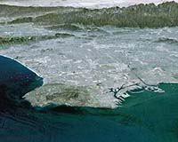
Amherst MA (SPX) Aug 26, 2005 An analysis by a University of Massachusetts Amherst scientist of the computer models that characterize the tectonics of the Los Angeles Basin suggests that five faults in the basin pose more of a seismic hazard than previously estimated. The new research, published in the latest issue of the Bulletin of the Seismological Society of America, makes significant progress in the extensive and ongoing effort to model the earthquake dynamics of the L.A. Basin. An accurate model will allow better assessment of Southern California�s earthquake hazard and more cost-effective risk-reduction solutions. "Knowing the tectonic setting helps us focus our efforts and gets us closer to understanding the true seismic hazard," said Michele Cooke, geosciences, who co-authored the study with her former graduate student W. Ashley Griffith, now of Stanford University. Their work was supported by the Southern California Earthquake Center, a consortium of more than 400 scientists at more than 50 research institutions and headquartered at the University of Southern California. SCEC is funded by the National Science Foundation and the U.S. Geological Survey. Southern California is like a complicated three-dimensional jigsaw puzzle, with the pieces constantly and slowly shifting against each other. This slow movement leads to strain among the pieces, which is relieved during an earthquake. In recent years, there has been a great effort to monitor this shifting throughout the Western United States using global positioning systems. GPS can track the "pieces of the puzzle" and help scientists learn more about exactly how the pieces fit together and move relative to one another. Different approaches in the analysis of GPS data, however, can lead to different conclusions about how tectonic forces may be acting upon the basin. The tectonic boundary condition for the L.A. Basin falls somewhere in between escape tectonics, where compression along one horizontal axis is relieved by expansion in another; and vertical thickening, where accumulated strain can�t escape and is accommodated by thickening of geologic layers. Most L.A. Basin models contain components of both escape tectonics and vertical thickening. To figure out which model is most accurate, Cooke and Griffith applied four different tectonic boundary conditions based on different analyses of GPS data. They compared slip rates generated from the 3-D computer models with geologic slip rates collected from surface observations, trenches, and seismic data. None of the models was a perfect fit for the observed data. The best fit, however, was the model that describes the basin as undergoing north-south contraction and only a very small degree of, if any, east-west extension. This model specifies that the basin is most likely accommodating the north-south contraction with vertical thickening of its geologic layers rather than through escape tectonics, which describes the accumulated strain exiting the basin like a pinched watermelon seed. Using the best-fit model, Cooke and Griffith then compared observed and modeled data for slip rates and slip-vector rakes on specific faults. They concluded that five faults in the Los Angeles Basin for which slip rates are uncertain�San Gabriel, Hollywood, Raymond, Chino and Peralta Hills�are moving relatively quickly. While paleoseismologists have determined horizontal slip rates for some of these faults, they need more geologic information about the vertical component of slip on these faults, which is enhanced by the vertical thickening in the region. The best-fit model indicates a fast vertical-component of slip on these faults due to the vertical thickening in the region. Because the probability of a damaging earthquake is generally proportional to slip rate, these faults may pose more of a hazard than currently estimated. "We know that the L.A. Basin is being squeezed along a north-south axis and wanted to find out if its response is primarily to extend in an east-west direction or to make the earth�s crust thicker," says Cooke. "Now that we know more about the tectonic setting of the basin, we can proceed with investigating the finer details of the model." Community Email This Article Comment On This Article Related Links University of Massachusetts Amherst SpaceDaily Search SpaceDaily Subscribe To SpaceDaily Express Tectonic Science and News
 Hyderabad, India (AFP) Dec 16, 2005
India said Friday it would not share information on earthquakes below a magnitude of six on the Richter scale due to security concerns, drawing criticism from the United Nations. |
|
| The content herein, unless otherwise known to be public domain, are Copyright 1995-2006 - SpaceDaily.AFP and UPI Wire Stories are copyright Agence France-Presse and United Press International. ESA PortalReports are copyright European Space Agency. All NASA sourced material is public domain. Additionalcopyrights may apply in whole or part to other bona fide parties. Advertising does not imply endorsement,agreement or approval of any opinions, statements or information provided by SpaceDaily on any Web page published or hosted by SpaceDaily. Privacy Statement |