|
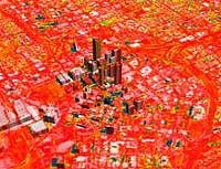
Greenbelt - Feb 13, 2004 While cities provide vital habitat for human beings to thrive, it appears U.S. cities have been built on the most fertile soils, lessening contributions of these lands to Earth's food web and human agriculture, according to a study by NASA researchers and others. Though cities account for just 3 percent of continental U.S. land area, the food and fiber that could be grown there rivals current production on all U.S. agricultural lands, which cover 29 percent of the country. Marc Imhoff, NASA researcher and lead author of a current paper, and co-author Lahouari Bounoua, of NASA and University of Maryland, College Park, added that throughout history humans have settled in areas with the best lands for growing food. "Urbanization follows agriculture -- it's a natural and important human process," said Imhoff.Throughout history, highly productive agricultural land brought food, wealth and trade to an area, all of which fostered settlements. "Urbanization is not a bad thing. It's a very useful way for societies to get together and share resources," said Bounoua. "But it would be better if it were planned in conjunction with other environmental factors." Studies like this one, which appears in the current issue of Remote Sensing of Environment, may lead to smarter urban-growth strategies in the future. The researchers used two satellites offering a combination of daytime and nighttime Earth observation data and a biophysical computer model to derive estimates of annual Net Primary Productivity (NPP). NPP measures plant growth by describing the rate at which plants use carbon from the atmosphere to build new organic matter through photosynthesis. NPP fuels Earth's complex food web and quantifies amounts of carbon dioxide, a greenhouse gas, which plants remove from the atmosphere. Nighttime-lights data from the Defense Meteorological Satellite Program and a vegetation-classification map created at NASA's Goddard Institute of Space Studies, New York, were used to portray urban, peripheral and non-urban areas across the United States. In this way, the researchers calculated the extent and locations of U.S. urban and agricultural land. In addition, observations from the Advanced Very High Resolution Radiometer instrument, aboard the National Oceanic and Atmospheric Administration's polar orbiting satellites, were used to calculate the Normalized Difference Vegetation Index. This index is a measure of plant health, based on the principle that plants absorb solar radiation in the red part of the spectrum of sunlight used for photosynthesis during plant growth. These data were then entered into a Stanford University computer model to derive NPP. The computer model created a potential pre-urban American landscape, which was used to compare and estimate the reduction of NPP due to current urban-land transformation. For the continental United States, when compared to the pre- urban landscape, modern cities account for a 1.6 percent annual decline in NPP. This loss offsets the gain in NPP of 1.8 percent annually from increased farmlands. The result is striking, given the small area that cities cover, relative to agricultural areas. A reduction of this magnitude has vastly unknown consequences for biological diversity, but it translates to less available energy for the species that make up Earth's complex food web. The loss of highly fertile lands for farming also puts pressure on other means to meet the food and fiber needs of an increasing population. On the local scale, urbanization can increase NPP, but only where natural resources are limited. It brings water to arid areas, and "urban heat islands" extend the growing season around the urban fringe in cold regions. These benefits, however, do not offset the overall negative impact of urbanization on NPP. NASA scientists developed the city lights map, and the U.S. Geological Survey used a technique to create the Normalized Difference Vegetation Index data. Research partners include the University of Maryland's Earth System Science Interdisciplinary Center, the World Wildlife Fund, and the Center for Conservation Biology at Stanford University. Community Email This Article Comment On This Article Related Links More at Goddard Top Story SpaceDaily Search SpaceDaily Subscribe To SpaceDaily Express Earth Observation News - Suppiliers, Technology and Application
 New York NY (SPX) Jan 11, 2006
The importance of remotely sensed data and technologies to support natural disasters has prompted attention and action in Washington. New initiatives and legislation authorizing appropriations to the remote sensing industry will be discussed at Strategic Research Institute's U.S. Commercial Remote Sensing Industry conference, scheduled for February 9-10, 2006 in Washington D.C. |
|
| The content herein, unless otherwise known to be public domain, are Copyright 1995-2006 - SpaceDaily.AFP and UPI Wire Stories are copyright Agence France-Presse and United Press International. ESA PortalReports are copyright European Space Agency. All NASA sourced material is public domain. Additionalcopyrights may apply in whole or part to other bona fide parties. Advertising does not imply endorsement,agreement or approval of any opinions, statements or information provided by SpaceDaily on any Web page published or hosted by SpaceDaily. Privacy Statement |